Sunday, September 16, 2012

Exeter - Canals, Castles and a round of mini-golf

After our last 'Chester' walk through the flooded Nene Valley - it was a relief to have our feet on solid ground again, as we walked down the Exe Valley to Dawlish Warren, on the south coast. 

War memorial in Northernhay Gardens
This was our first Chester walk in Devon and is as far west as we're going to go in this walking series. Exeter was also at the limits of Roman influence in the south west of England.  There are remains of the Roman wall in the city and Roman baths were excavated in the 1970's.  Exeter was also the starting point for one of the most famous Roman roads, the Fosse Way which runs all the way to Lincoln, passing a few other 'chesters' (Ilchester and Leicester) on the way! 

Known as Isca Dumnoniorum in Roman times, it's quite likely that Exeter was the site of a substantial Celtic settlement - the word isca could be related to the Celtic word for 'water' (if you compare modern Irish - uisce, pronounced ish-ka, also the basis for the word whiskey).  When the Saxons arrived, they called it Eascanceaster which became Exeter in modern English). 

Part of Exeter Castle

It's interesting how our walks in modern 'chesters' often involve three aspects of British history; a Celtic root word, somehow incorporated into the placename - evidence of a Roman settlement - the addition of the word ceaster by the Saxons.  There were other important Roman settlements in England like Bath and St Alban's but, for whatever reason, they didn't inherit the Saxon ceaster and, therefore, won't feature in our 'Chester' walks!

Lodgings and Victuals

My Best Aussie Mate (BAM) had spent a few days in Exeter before and is somewhat enamoured with the place, so she acted as my guide for this walk - showing me interesting corners of Exeter, like the Victorian-era catacombs of St Bartholomew's Cemetery or the gorgeous Georgian buildings on Northernhay Street.  We stayed in a grand old building on Blackall Road, which is now Raffles B&B and we had dinner at the wonderful Fat Pig Freehouse on John Street.  I'd recommend the Fat Pig - not only for its delicious, locally sourced menu, but also for their home-made cider!

Cider at The Fat Pig, Exeter
Part of Exeter's Roman wall


Exeter Quayside to Double Locks (1.6 miles)

We started our walk at Exeter's historic quayside - a photogenic place that attracts a lot of tourists.  Exeter has had a quayside since Roman times and this is also the location of a Canal basin for the Exeter Ship Canal that was started in the 1560's - one of England's oldest man-made waterways.  We were following the Exe Valley Way, a 45-mile walk from Starcross (Devon) to Hawkridge (Somerset).  Quite bizarrely, the path crosses the Piazza Terracina with its Italian-style restaurants - the square is named after Exeter's twin-town in Lazio.  Both Exeter and Terracina suffered heavy destruction during World War Two, so I guess the town-twinning was recognition of this common experience.

Exter Historic Quayside


The path from Exeter Quayside to the Double Locks is a pleasant one, although quite busy with other walkers, families and cyclists.  The Double Locks is so-called, because it can accommodate two ships at once.  The lock-keepers cottage is now a popular canal-side bar and restaurant.  I was quite fascinated by the 'snail wall' which you can see in the photo. 

The Snail Wall

The Double Locks


Double Locks to Turf Lock (3.7 miles)

This part of England has strong historical connections with Holland and the canal locks on the Exe show some Dutch influence.  Exeter was once an important centre in England's wool trade and, as we were walking along the path to Turf Lock, you could almost picture the ships laden with cargo, making their way to continental Europe, or returning to Exeter after a long sea passage. 


The path gets further from civilisation, finally leaving the city behind, as you pass under the M5 road bridge.  The first section of the M5 was opened in the 1960's and it runs all the way to West Bromwich, just outside Birmingham.  Myself and BAM were glad to see it go, carrying all of those noisy cars with it, as we passed underneath and strode out into the proper countryside.

Open countryside near the Double Locks
 In the 19th century, a decision was made to extend the Exeter Ship Canal an extra two miles to Turf Lock, where the Exe estuary carries a distinctly sea-perfumed breeze.  On the other side of the river lie the lands of Countess Wear and a village called Topsham, with its Dutch gable houses.  An erstwhile rival of Exeter, Countess Wear is named after a real countess, Isabella de Fortibus, who tried to sabotage Exeter's influence in the 13th century by building a weir that would divert trade to Topsham.  Vivien Leigh had local connections to Topsham and, although we could only see it at a distance, I'd love to visit the village properly, including the local museum, which holds a collection of Leigh memorabilia.

Swan at the Topsham Ferry lock
View of Topsham, across the river


Like the Double Locks, Turf Lock was once a lock keeper's cottage, but is now a very pleasant pub and restaurant.  They also offer accommodation and have a campsite, which seemed really busy with late-summer holiday-makers. 

The Turf Lock Hotel


Turf Lock to Powderham Castle (1.8 miles)

Passing Turf Lock, the Exe river begins to take on some of the grandeur of the open sea and is fully navigable, evidenced by the local ferries that criss-cross the river at this point.  This area is great for spotting migrating birds and waders and we saw a few 'twitchers' along this stretch, excitedly clutching their cameras and binoculars. 

As the Exe opens out to the sea

The path continued, with some disruption because of repair work, now paralleled by the inland railway line, which runs along the coast from Exeter to Plymouth.  We eventually crossed the railway line and found ourselves on Church Road, named after Powederham Church, the so-called 'church without a village'.  The road was relatively busy with cyclists and cars, so perhaps not the most pleasant part of the walk. 

Last view of the coast before turning inland


We could see the stately Powderham Castle in the distance, home to the de Courtenay (short-nosed?) family, the Earls of Devon.  It's not often that the Norman history intrudes on our Celtic-Roman-Saxon walks and Powderham Castle is a good reminder of the inherited privilege and wealth that still exists in England, having been handed down from generation to generation.  It looks like a stunning building and the interior has been used for filming movies like Remains of the Day. 

Powderham Castle hidden amongst the trees

The current (18th) Earl of Devon is the Oxford-educated British peer, Hugh Courtney.  He got into trouble in 2009, when he refused to let Powederham Castle be used for civil partnerships (state-recognised union of same-sex couples), citing religious objections.  This incident led to Powderham Castle losing its license to hold both marriages and civil partnerships.  Needless to say, BAM and I strongly disapprove of Lord Devon's narrow-mindedness and we believe in a world where people are shown respect, regardless of their sexual orientation. 

Powderham Castle to Starcross (1.2 miles)

Just before Starcross, we joined the even busier A379 - the railway line commands the coastal route at this point and I tried not to feel envious of the railway passengers enjoying the view of the Exe estuary, as we trudged along the inland roadside.  I had extremely high hopes for Starcross - not only, did I envisage comely villagers doing star-jumps on the village green to welcome us, but I also imagined balconies full of Shakespearian teenagers, declaring their eternal love.  Unfortunately, the reality was a lot shabbier and it seemed as though the most exciting thing happening in Starcross involved mini-golf (although, admittedly, at quite a reasonable rate!). 

But not a whisper of star cross'd lovers!


Starcross to Dawlish Warren (2.4 miles)

Starcross is the official starting (or ending) point of the Exe Valley Way but, as we'd made it in good time, we decided to extend our walk further south to the next railway station at Dawlish Warren, just opposite Exmouth.  Despite it's slightly embarrassing name, Cockwood was a much more picturesque place than Starcross and, as we walked by, we watched holiday-makers enjoying sundowners in the Anchor Inn, beside a small river estuary flowing into the Exe. 

Cockwood village
We followed a path that runs for another couple of miles alongside the Dawlish Warren road and, even sooner than expected, we were in Dawlish Warren itself, a not-unpleasant seaside resort full of caravan sites and bucket-and-spade shops.  As we caught the last rays of summer sunshine, we had time for a leisurely late-afternoon meal, before hopping on the train back to Exeter and on to London. 

The beach at Dawlish Warren


Access for Wheelchair Users

Anyone for mini-golf?
I'm pleased to say that most of this route was accessible for wheelchair users.  Certainly, I'd recommend the first few stages from the Exeter quayside to Turf Lock.  There are several parallel paths, but a great cycle path which is accessible for wheelchair users or others with limited mobility.  As far as I can remember, the bridge that crosses to the Double Locks pub is inaccessible, however, there seemed to be an accessible bridge crossing the canal at the Turf Lock, which would make a sensible end-point for a wheelchair user.

Beyond Turf Lock, the path was obstructed by repair work and inaccessible, but I presume this is a temporary situation.  The rest of the walk to Dawlish Warren was accessible, but with lots of road walking/wheelchairing, so watch out for traffic and cyclists!


Image credits:

All photos were taken by me, please feel free to reuse, under the Creative Commons license:

- Attribution (especially to this blog post)
- Share alike
- Non-commercial

Sunday, July 22, 2012

Irchester - Nettles and Nasty Mosquitoes in the Nene Valley

The Irchester walk was our 13th 'Chester' and my first time walking in Northamptonshire.  It's one of those obscure counties, somewhere in the middle, that most Londoners would be hard pushed to pinpoint on a map. It only took us 50 minutes to get to Wellingborough from St Pancras, which is a reasonable commute for anyone who works in London, but lives elsewhere.

Lodgings


We decided not to stay in Wellingborough, but further out in the countryside, in a small village called Chelveston, so we could walk back towards 'civilisation' the following day.  Middle Farm Villa BnB was a lovely place to stay and we were given a nice welcome by the owners.

Middle Farm Villa BnB, Chelveston

After dropping our bags off, we headed across the road to the village pub, The Star and Garter, for a swift drink and a chance to sample local life!  The locals seemed really friendly and we got involved in a weekly draw, based on the 80's TV show, Play your cards right, where you have to guess whether or not the next card is going to be higher or lower than the one before.

The Star and Garter in Chelveston


Luckily for us, we didn't get chosen to participate - I think being thrust in the limelight, as complete strangers, would have been too much for BAM (Best Aussie Mate).  The three participants who were chosen failed to guess correctly, so the jackpot has rolled on until next week.

Walk disclaimer


This had to be one of the most difficult walks we've ever done and, unfortunately, I wouldn't really recommend it - at least not right now!  There has been a lot of rain in England this summer and the East Midlands are particularly susceptible to flooding, the Nene valley being no exception.  What's more, the 'Recreational Walk', the Nene Way, is badly maintained, being completely overgrown in some parts and blocked off on others.  Perhaps there will be in improvements in the future, but right now, it's not passable.

Chelveston to Stanwick Lakes (1.6 miles/2.6 km)


We set off early from Chelveston, walking along Water Lane, we discussed the passion and enthusiasm of Peter Garret from Midnight Oil before turning onto a small public footpath leading through a wheat field.  BAM told me about an incident involving her kayaking club in East London, due to current overcrowding on the Thames and we discussed the concept of 'Right of Way' - how it has more or less been protected on land, but is very difficult to enforce on water.

Path through wheat field leading off Water Lane, Chelveston

Field beside Chelveston Lodge


We continued following the path along the bottom of some fields, past a farm called Chelveston Lodge and, eventually, we came out onto Stanwick Road.  Another effect of the recent rains has been an explosion of plant growth - I've never seen the English countryside looking so green, it's almost as green as Ireland!  Also, the nettles and thistles are thriving, so we got stung and scratched a lot, as we climbed through hedgerows and walked along the field edges.  The weather was fantastic for a change and it was so lovely to be outdoors enjoying the sunshine, even if we were looking a little bit burnt at the end of the walk!

Hedgerow on Stanwick Road

Crossing Stanwick Road, we walked through a couple of fields, before crossing the A45 to reach Stanwick Lakes.

Stanwick Lakes to Irthlingborough (1.8 miles/2.9 km)


Stanwick Lakes is a lovely area full of fishing ponds.  The Nene valley had lots of ironstone and gravel deposits, so the river valley has been heavily quarried in the past and the former quarries have filled with water, creating a series of artificial lakes.  Stanwick Lakes has recently been designated a country park and I'm sure that it's normally a lovely place to visit but, because of the floods, we found that the paths we wanted to follow were completely inundated.  Unfortunately, after twenty minutes or so of wading knee-deep through water, we had to backtrack to the A45 and walk along the verge to a roundabout, where we picked up a smaller road leading to Irthlingborough.

BAM on path in Stanwick Lakes

It's a nice spot to do some fishing!


It's never pleasant walking on roadside verges and the A45 is quite a busy road, linking Northampton to the A14.  Turning down Station Road, we passed a Scrap merchant and a caravan park before picking up the Nene Way, just opposite the Nene park Industrial Estate.  Walking along the upper end of a field, we passed some beautiful old buildings at Nene View, then followed a back lane, which runs behind the village, until we came to St Peter's Church.


St Peter's Church in Irthlingborough
I really loved the design of St Peter's Church at Irthlingborough - it has a 'lantern tower', which looks out of place in the English countryside, making me think more of Tuscany or Andalusia!  From the church we made our way to the High Street, for a short break and the chance to stock up on water.


Irthlingborough High Street
Irthlingborough to Higham Ferrers (2.5 miles/4 km)


The next part of the walk was probably the most beautiful, heading downhill from St Peter's Church, through the water-meadows of the Nene Valley.  The path was completely water-logged in parts, but manageable.  The Nene Way follows a dismantled railway line at this point, which used to run trains between Northampton and Peterborough, but was closed down in 1964.  As the path hooks around Station Road, we lost it again, whether because it's overgrown or has disappeared under the water, so we made our way back up to Station Road, back to the roundabout at the A45!

Water-logged path

Dismantled railway line


We followed the A45 for a little bit, before picking up the Nene Way again at a pedestrian flyover leading to the village of Higham Ferrars.  The walk into Higham was lovely, along a back street, past the ruins of the castle and Chichele College.  Higham had a nice 'feel' about it and I'd imagine it's a lovely place to live.  BAM got momentarily fixated on the fact that the flat above the Sweet Shop was for rent, but I managed to snap her out of her reverie and remind her of London and responsibilities!

River Nene with sky reflected

Street corner in Higham Ferrers

Higham Ferrers to The Sewage Works (1 mile/1.6 km)


The next part of the walk was well sign-posted, from Higham Ferrers downhill, crossing a pedestrian bridge over the A45 to the Higham Ferrers nature reserve.  We continued following a clear foot path through the reserve until we came to the grounds of a local Sewage Works, where we came completely unstuck!  Whether the Nene Way had completely disappeared under the water at this point, or it had been blocked off, wasn't really clear, but we came to a dead end, as soon as we crossed a footbridge over a weir and ran into the Sewage Works fence.  Our problem-solving skills were called into action, so we studied the map and managed to find an alternative detour around the back of the Sewage Works and back on to the Nene Way at Ditchford Bridge.

River doesn't look very healthy?

River Nene with A45 running alongside

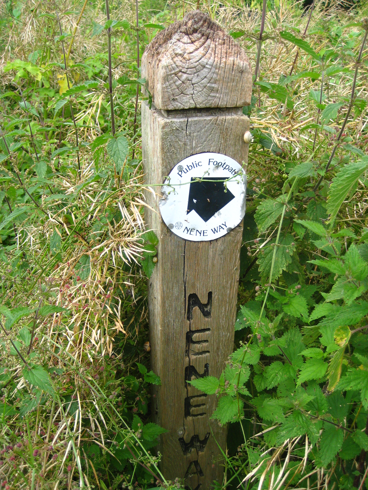
Sign post for Nene Way overgrown with nettles!

Detour: The Sewage Works to Ditchford Bridge (2.3 miles/3.7 km)


This was probably the hardest part of our walk, as we tiptoed across a dilapidated railway bridge and hacked our way through dense undergrowth beside a disused pit, whilst being dive-bombed by particularly nasty mosquitoes - it felt like we'd suddenly been transported to the Thai jungle!  There was no defined path, so it was quite a physical challenge to get out of the nature reserve and back towards civilisation.  By the time we stumbled onto the shockingly suburban Lodge Way, we looked like survivors of a jungle expedition gone wrong.  BAM noted that it's probably the closest we'll get to experiencing I'm a Celebrity . . . and I think that's a good thing too!

Dismantled railway bridge near Sewage works
Where we'd ended up was actually the far end of Irthlingborough and it was a little disheartening to feel like we'd spent the day going round in circles!  We walked along Lodge Way to Waterloo Way, then followed Thomas Flawn Road onto the main Wellingborough Road, at the end of Irthlingborough village.  Thomas Flawn was a soldier in the British army, born in Irthlingborough, who was awarded the Victoria Cross for bravery when he saved the life of his lieutenant during the Basuto Gun War (modern-day Lesotho) in the 1880's.

Walking along the Wellingborough Road was really unpleasant, with cars speeding past us recklessly, we stumbled along the verge, kicking up crushed beer cans and other random bits of rubbish.  Eventually, we came to a cross-roads and turned down the slightly less offensive Ditchford Road, until we rejoined the Nene Way at Ditchford Bridge.

Ditchford Bridge to Wellingborough Station (2.1 miles/3.4 km)


The next part of the walk was a pleasant stroll through water-meadows, under a lovely railway viaduct until we reached a footbridge leading to Irchester.  Unfortunately, this was to be our conclusive disappointment of the day, as the footbridge has been closed by the local authority, for Health and Safety reasons, which meant we had to miss Irchester altogether and find another way out of the water meadows, so we would get back to Wellingborough Station in time to catch our train back to London.  It was a shame to miss Irchester and walk through the country park but, as geography, time and the local authority were conspiring against us, we had to settle for a distant view of Irchester church and the site of the old Roman settlement on the other side of the river!

Railway viaduct with horses

Closed-off footbridge leading to Irchester

Access for Wheelchair Users


One of the many obstacles for Wheelchair Users
I was quite hopeful, when planning this walk, that there would be a certain amount of accessibility for Wheelchair users.  When it came to the reality of the walk, accessibility proved to be incredibly difficult, even for able-bodied walkers, with lots of fences, gates and other obstacles that needed to be climbed over.  The only bit I could recommend, although it's currently inundated, is the walk from Irthlingborough through the water meadow and along the dismantled railway track.  


Unfortunately, a metal kissing gate on the pedestrian flyover blocks access for wheelchair users hoping to go to Higham Ferrers, however, an alternative might be to follow a cycle path from the other side of Station Road which runs all the way to Thrapston.  We didn't follow this route though, so I can't really recommend it.  


Image credits:


All photos were taken by me, please feel free to reuse, under the Creative Commons license:

- Attribution (especially to this blog post)
- Share alike
- Non-commercial


Sunday, May 20, 2012

Ribchester - Weavers and Witches in Middle-Earth

Ribchester was our first foray into the wilds of Lancashire!  It's located between Preston and Blackburn, in the Ribble valley (hence the name), a beautiful spot that feels a million miles away from the big towns and cities that surround it.  I'd been in the Ribble valley before, having finished a walk of the Yorkshire Dales at Ribblehead, near the source of the Ribble river, but it was BAM's first time in Lancashire, so we were very excited to get out into the countryside and find out what the North West is all about!

Lodgings

As it's summer, accommodation options are much in demand and most places, including the Ribchester Arms (unfortunately) require a minimum two-night stay.  We were a bit pushed for time on this trip, so we could only stay one night and chose the Rose Cottage BnB in nearby Clayton-le-Dale instead.  It was a cosy place and we received a nice welcome after our long train journey from London and taxi ride from Preston station.  It was quite late when we arrived at Rose Cottage, so we didn't get to see much of Clayon-le-Dale. 

Longsight Road to Ribchester bridge (1.8 miles)

To get to the River Ribble we started by taking a bridleway opposite Rose Cottage, on the Longsight Road.  We passed a couple of gorgeous little lambs, who looked suspiciously well-fed and we wondered whether or not they were destined for one of the local restaurants!  Not far down the bridleway we turned left onto a small path past a pond with very serious looking fishermen, then climbed over a stile into a rather messy slurry pit, a not so great start to the day.  Trudging through slurry left us with a very pungent aroma of cow manure that I'm still struggling to forget! 

The slurry pit lay right on the path of an old Roman road, which we followed down to a ridge overlooking the Ribble valley.  At the ridge, we got our first real view of the valley, then turned right on a public footpath which brought us to a car park at Barker Brow and the B6245.  We followed the pedestrian footpath along the road downhill to Ribchester bridge. 

Lambs at Mire Fold, off the Longsight Road

View towards Ribchester and the Ribble Valley

Ribchester Bridge, taken from the Blackburn side


Ribchester Bridge to Haugh Wood (0.8 miles)

At Ribchester Bridge we turned right along the Ribble Way and headed north, in the opposite direction to Ribchester.  The Ribble Way is a long-distance footpath that runs for 65 miles (105km) from the Ribble estuary at Longton, just south of Preston, to Gayle Moor in North Yorkshire, where the source of the river can be found.  The Ribble seems like quite a placid river, meandering along as though it's in no great hurry, we also meandered along and stopped in Haugh Wood to soak up the atmosphere and have a small picnic. 

A Ribble Way signpost

River Ribble, taken from Ribchester bridge

Beautiful carpet of flowers at Haugh Wood


Haugh Wood to Hurst Green (1.9 miles)

Just after Haugh Wood, the Ribble Way diverts across a field, away from the river.  We didn't quite do this, but followed the tree line of Coppy Scar Wood, above a bend in the Ribble.  Our conversation turned to the recent controversial case in nearby Rochdale involving young girls being targeted by a gang of sex-traffickers.  Nine men have been convicted of trafficking young girls and the case has sent a shock wave across the country and caused heated debates, a lot of which, unfortunately, have focused on race (8 of the men were of Pakistani origin and most of the victims were young, white girls). 

People often talk about race, when they really mean culture and I can't help thinking that the real 'elephant in the room' is, in fact, social class.  Most of the victims were vulnerable working-class girls, some of whom came from dysfunctional families.  In a country where young, working-class girls are constantly portrayed as being promiscuous, benefit-scroungers who get pregnant so they can get a flat from the council, it's hardly surprising that some men, regardless of their ethnicity, have no respect for these young women and see them as fair game. 

Lopsided sign post near Coppy Scar Wood

Crossing the fields below Hey Hurst, we got our first views of Pendle Hill, a place steeped in mystery and the supernatural.  It's probably most famous as the place where the 17th century Pendle Witch trials took place.  Ten people, mostly women, were convicted of witchcraft and hanged to death.  It's obvious from a modern perspective that these women weren't really witches, but victims of a ruthless campaign to rid Lancashire of 'religious heresy'.  Pendle was a bastion of Catholicism and this might have contributed to the witch-hunt in this area. 

Pendle Hill, where the 17th century witch trials took place

We like to think that the days of witch-hunting are over, but I often wonder if this is true, when I see minority groups being demonised and pilloried in the modern press.  17th century Lancashire was considered to be a wild and lawless region, fabled for its theft, violence and sexual laxity.  It's obvious that Lancashire has suffered from a lot of bad press over the years and I wonder how much of this is down to its historical role in the power struggles that forged modern England. 

Hurst Green, just as the sun came out!


Hurst Green to Greengore (0.85 miles)

If Hurst Green is anything to go by, then I can gladly confirm that Lancashire is not as wild and lawless as they make it out to be!  Hurst Green seemed like a lovely place.  As we had a rest on the benches in the centre of the village, the sun came out and it finally started to feel like May, instead of December!  We followed the road through the village, which passes The Bayley Arms and the entrance to the Dene (which leads to Shire Lane).  Apparently, JRR Tolkien's Middle-Earth was inspired by the local landscape and Tolkien wrote part of The Lord of the Rings when he was staying at the local Jesuit college in Stoneyhurst.

Rock formations at Mill Wood, inspiration for Tolkien's The Shire?

Certainly, the landscape had a magical quality, as we took a path through Mill Wood, past weird rock formations and small glades dappled with sunshine.  Amongst other things, Lancashire was famous for its weavers and textile industry.  As we walked through the woods, it felt as though we'd been transported to a different era and we got a glimpse of what England must have been like in bygone days. 

A dappled light worthy of the best Impressionist painter

A magical path through the woods


Unfortunately a lot of the larch in this area has been felled because of an outbreak of Ramorum dieback.  A terrible disease that mostly affects oak trees (it's also known as Sudden Oak Death), it kills healthy trees in a very short space of time.  I think ramorus comes from the Latin word ramus meaning 'branch'.  There were certainly lots of stockpiles of timber around the area, as you can see in the photograph (below).

It couldn't be England in May without the bluebells

The path to Greengore

Stockpile of timber


Greengore to Intack (0.9 miles)

The Ribble valley is full of wonderfully interesting buildings like Greengore farm, a 15th century building which has some self-catering accommodation and (rather bizarrely) has flying buttresses on the main building!  From Greengore we walked towards Crowshaw House and briefly joined the Old Clitheroe Road, where there are spectacular views over the Ribble valley.  We then took a small path past a disused quarry and into the grounds of Intack, a traditional detached farmhouse. 

View of the Ribble Valley from the Old Clitheroe Road

Path leading to Intack

Intack to Duddel Wood (0.7 miles)

The next part of the walk was very short, but took us a long time, as it was difficult to navigate the public footpaths in the fields between Intack and Duddel Wood.  The first bit, to Huntingdon Hall, was fairly straight forward, but we got really confused after that, as it was difficult to find the entrance to the wood.  We eventually found a way, over a fallen fence, and scrambled through the trees along a ridge above Duddel Brook.  Luckily, we found a stone bridge that brought us across the brook and out onto a neglected lane way, leading to the 19th century Dutton Manor. 
Getting lost in Duddel Wood

Duddel Wood to Duddel Hill (0.6 miles)

The lane way from Dutton Manor to the B6243 at Dean Brow is a rather enchanting place and is lined with old-fashioned electric lamp-posts that have fallen into disrepair.  I don't know enough about architecture and design to say what style the lamp-posts were in, but it had a feeling of the 1920's and I could almost hear the echo of newfangled motor cars driving up to Dutton Manor in the late evening for a fabulous party! At the entrance to the lane is a small gatehouse, known as the Beech House.

Lamp-post on Dutton Manor lane way

 At the Beech House, we turned right onto Dean Brow and, before it came to Moor Cock farm, we crossed the road and took a footpath on the left leading to Duddle Hill.

Beech House on Dean Brow (Longridge Road)

Duddel Hill to Ribchester (1 mile)

By the time we got to Duddel Hill, it was already quite late, so we covered the last mile downhill to Ribchester quite quickly.  The fields had been sprayed with manure, so we finished our walk in a similar fashion to how we'd started it!  Following a fairly obvious path downhill, we eventually came out onto Stydd Lane.  Passing two small churches and an almshouse that has been converted into apartments, we followed the lane back to the B6245, which is the main Blackburn Road.  At the road we turned right towards the village and made our way to the Ribchester arms for a well-deserved drink and hearty meal!

Field sprayed with manure, near Stydd Manor


Ribchester was known as Bremetannacum during the Roman era and the village still has some Roman ruins.  Archaeological artifacts, like the Ribchester Helmet, were found in the village.  Unfortunately, we didn't have a lot of time to explore Ribchester itself, as we had booked a taxi back to Preston and our onward train to London. 

Ribchester, site of Roman Bremetannacum
Access for Wheelchair Users:

Unfortunately the first part of the walk we did would not be accessible for wheelchair users, however, an alternative walk from Clayton-le-Dale (or even Blackburn) would be possible, as there is a path for pedestrians along the B6245.

The Ribble Way was accessible from Ribchester Bridge to Dewhurst House - after this, the route we followed was not accessible again until the lane way leading from Trough House to Hurst Green.

The most beautiful part of the walk, from Hurst Green to Intack was mostly accessible, as the path seemed pretty smooth.  There were some gates that needed to be opened and closed along the path. 

The bit between Intack and Ribchester was inaccessible, as it crossed fields, however an alternative route might be along the Huntingdon Hall Road and Gallows Lane, if you feel comfortable wheelchairing on small country lanes with the risk of traffic.  I haven't been on these roads, but I'd imagine they are quite steep in parts.  Definitely one for more adventurous wheelchair users!

Image credits:

All photos were taken by me, please feel free to re-use them under the Creative Commons license:

Attribution (especially to this blog)
Share-Alike
Non-commercial