Sunday, July 10, 2011

Silchester - Calleva Atrebatum

Signpost for Roman Silchester
Like Wroxeter, which we visited in March of this year, Silchester - known to the Romans as Calleva Atrebatum - didn't really take off as a settlement in modern times.  Most people would be hard pushed to pinpoint Silchester on a map and myself and BAM (Best Aussie Mate) were no exceptions, before we did this walking trip!

The modern-day village of Silchester is located in the north of Hampshire, in the countryside between Basingstoke and Reading, just outside a town called Tadley.  Although there is a hotel in Silchester, the reviews were off-putting, so we did some research and decided to start our walk in Stratfield Mortimer in Berkshire.  Mortimer station is located, quite handily, on a small branch line that runs between Reading and Basingstoke.  Although it's a small line, it dates back to the early days of rail travel and the station and line has been in operation since 1848!
Reading to Basingstoke line

Like a lot of railway stations around Berkshire and Oxfordshire, Mortimer station is quite far from the main village of Mortimer Common.  It might seem a bit incongruous to 21st century travellers, but I believe this is evidence of a stubborn compromise for 19th century villagers who weren't all that interested in having steam-driven technology ploughing through their idyllic lives.

Victuals and lodging

We travelled down from London Waterloo, via Basingstoke, arriving at Mortimer just in time for a delicious curry at a popular local restaurant called The Cinnamon Tree.  Time-travelling 19th century Mortimerians might well be bewildered by a restaurant in their village specialising in Bangladeshi and Indian cuisine, but we were well-pleased, feasting on Misty Lau and Murgh Jalfrazi.

Our room at the B&B
Little Park Farm B&B


BAM had booked us in to a lovely B&B called Little Park Farm, which is in a 19th-century farmhouse, a short distance from Mortimer station.  We stayed in a Twin room in the loft, with lovely views over the surrounding countryside.  For city-dwellers like us, it's great to wake up in the countryside, with the smell of bacon being fried in the kitchen and the sound of birds twittering in the garden.  Once we'd had our fill of food and coffee, we ventured out into the countryside and set off in the direction of Silchester.

Little Park Farm to the Devil's Highway (1.2 miles)

BAM walking through a field of wheat
Like most Roman settlements, Calleva Atrebatum had a Roman road, which ran from modern-day Silchester all the way to London.  As it passes through this part of Berkshire, the Roman road is known as the Devil's Highway, although I couldn't quite find out why it's called this.  Perhaps, it was related to the fact that the road brought Roman invaders to what was a regional Celtic capital?  Perhaps, the name comes from a later time, when weary travellers along this road would have journeyed in fear of footpads and highwaymen?  Whatever the reason, the name in itself was enough to attract our attention, so our first 1.2 miles involved a loop from Little Park farm, walking down the farm driveway to the main Beech Hill road (known, oddly, as The Forehead).  Opposite Perrins Farm, we turned onto a public footpath leading through some beautiful wheatfields, which eventually brought us onto the Devil's Highway at the Home Farm, just outside Fair Cross.

The Devil's Highway
Yesterday's weather was a bit unsure of itself and our arrival at the Devil's Highway was greeted with a shower of rain which, in the nature of English showers, decided to finish, as soon as we'd got our raincoats out of our bags.  We noticed a group of young people with maps standing at the junction to Fair Cross, looking a bit uncertain as to whether or not the Devil's Highway was the right option for them.

The Devil's Highway to Calleva Atrebatum (3 miles)


Roman roads are very easy to walk on!  They're straight, for a start, so no chance of getting lost and, unlike most of the main Roman roads, which have been superseded by national highways and motorways, the Devil's Highway to Calleva Atrebatum is, blissfully, devoid of modern phenomena such as trains, planes or automobiles!  We passed south of Little Park Farm again, then through Butler's Land, where we passed another group of young people with maps and then crossed onto a small country road leading to a railway bridge.

Field full of cornflowers
We were quite startled when a silver-haired lady called Ann suddenly appeared from a gap in the hedge.  As it turned out, she is a local leader for the Duke of Edinburgh awards and had been looking for some of the same young people we'd seen wandering around the area with maps! We had a quick chat, then crossed the railway bridge, coming to a T-junction, where we left the road and crossed a hilly field full of the most amazing cornflowers, daisies and poppies.  The end of the field brought us onto the road again and the amphitheatre of Calleva Atrebatum.

Calleva Atrebatum to Silchester (0.8 miles)

The Amphitheatre at Calleva Atrebatum
The Roman name for the settle Calleva Atrebatum could possibly have been adapted from a local Celtic name that translates something like, 'wooded place where the Atrebates tribe live'.  Calleva sounds like a Romanisation of the Celtic word for wood/forest, if you compare the Irish word coillte or the Welsh coedwig.  I wonder if the origin of the name Silchester, also has its roots in the Latin word for wood/forest Silva? The Atrebates occupied most of modern-day Berkshire and they were unusual in that their culture seems to have more in common with Belgic tribes living in (modern-day) France, than the other Celtic tribes that were living around them in Britain.

The churchyard at St Mary's
Wedding guests
One mystery surrounding the Celtic settlement at Calleva Atrebatum was the fact that a stone with Ogham script was found on the site.  Ogham is mostly associated with Ireland and there are very few examples of Ogham script in England, the others being found exclusively in Cornwall in Devon.  The presence of Ogham in Silchester is attributed to a lone Irish settler, so perhaps, with its Belgic and Irish connections, Calleva Atrebatum was an ancient melting-pot of Celtic cultures?

Another mystery surrounding the site is the reason for its having been abandoned.  During the Roman times, it's believed that several thousand people lived in Calleva Atrebatum.  The site not only contained an amphitheatre, which you can still see today, but also Roman baths, temples, a mansion and a Forum Basilica.  According to The Guardian's Heritage writer, Maev Kennedy, in her article from 1999, the site might have been cursed by the Anglo-Saxons, evidenced by ritualistic remains involving a dog's bones!

Silchester Town Life Project
Excavation at Silchester Roman site
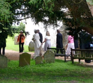
Whatever the reason for its abandonment, Calleva Atrebatum has an air of otherworldiness about it.  Just inside the walls of the site is a beautiful church called St Mary the Virgin.  We stopped for lunch in the churchyard and watched wedding guests milling around the church, congratulating a newly-married couple.  We then continued our walk through the heart of the ancient settlement, passing a group of young excavators from the Department of Archaeology at the University of Reading, who are currently working on the Silchester Town Life Project.  Eventually we came to a road at the edge of Silchester, where we turned around again in the direction of Mortimer.

Silchester to Mortimer (1.4 miles)

Sign post for Wall Lane
We had to walk along a fairly busy road, past Catthawlands Farm, before turning onto a quieter road called Wall Lane and back-tracking past the Roman walls and onto a public bridleway that took us all the way to Mortimer.  We had intended to take a smaller public footpath to Mortimer, rather than the bridleway, but I'm glad we went the way we did, as the bridleway passed through some lovely countryside, full of sheep and horses, past the Nine Acre copse and Simms Stud Farm, which is on the outskirts of Mortimer village.

Horses at Simm's stud farm
The wedding at St Mary's and the bridleway passing a stud farm has us thinking about all kinds of horsey-matrimonial connections we'd never thought of before.  It's interesting that the word groom is used mainly in two contexts, ie. a man who is getting married (or has just got married) and the person who looks after a horse.  It's also interesting that the word bride is very similar to the word bridle, ie. the idea that young, free women are bridled by marriage and reigned in by their new husbands, who are, by definition 'house bound'.  Horses were incredibly important to the development of modern technologies and societies, but it's not very flattering for a young woman to be described in language usually reserved for horses! 

Boundary marker
Another thing that caught our eyes on the way into Mortimer was an old boundary post, which marked the border between Hampshire and Berkshire.  I'd seen references to these on my Ordnance Survey map, but this is the first one we've spotted!

Mortimer to Wokefield Common (2.3 miles)

Wood for the signs?
The rain came on again as we sat at the church in Mortimer.  Mortimer seems like a nice place - quiet Berkshire village life went on all around us, as we sat munching our chocolate Koala bears!  Passing a playing field, we skirted around the north of the village and then took a path through Starvale Woods, eventually leading us to Wokefield Common on the edge of a village called Burghfield Common.  The woods were really beautiful, but it's always harder to orientate yourself in woodland and the bewildering array of signs for public footpaths and bridleways meant we couldn't see the wood for the signs! 

We got a little bit lost, but eventually made it to a crossroads, where DoE Ann spotted us and stopped her car to give us an update on her groups and an interesting history lesson about Mortimer Common and the Silchester Roman site.  We would loved to have spent more time talking to her, as she seems to know her local history really well, but time was pushing on and we had a train to catch.

Wokefield Common to Mortimer Station (2 miles)

Wheat fields
The last two miles brought us down Lockram Lane, then through some amazing wheatfields and hilly country, passing over Lockram Brook, we took a wrong turning and detoured down to Mann's Farm, then walked along the road to Wheat's Farm where we joined our original path, going downhill to Mortimer Station, just in time for our connection to Basingstoke and back to London.   

Access for Wheelchair Users

Wokefield Common
Again, I'm basing this on someone using a heavy, electric wheelchair.  I would start this walk at Beech Hill, rather than Little Park Farm or Mortimer Station.  The second part of the walk I've described above, along the Devil's Highway, is completely accessible and relatively smooth-going, until you get to the T-junction before Calleva Atrebatum.  At the T-junction you could turn left along a small country lane, then right to the gates of St Mary's Church.  The Roman site seems to be, for the most part, wheelchair accessible.  We didn't walk on the walls of the site but, from a distance, they looked really inaccessible to wheelchair users.  

Church at Stratfield Mortimer
I wouldn't recommend wheelchairing along the roads around Silchester and the bridleway to Mortimer was also not accessible.  Some of the paths in Wokefield Common seemed accessible, but the rest of the route described above, especially the last two miles, would not be accessible, unfortunately.  


Image credits:

All images were taken by myself or BAM, please feel free to use these images under the following Creative Commons license:

Attribution (especially to this blog)
Share-alike
Non-commercial 

Sunday, May 22, 2011

Dorchester - Durnovaria

Sign at South Dorchester Rail

Thomas Hardy statue in Dorchester
 The walk we did yesterday in Dorchester was our first foray into the Chesters of South West England.  I've been a big fan of Thomas Hardy since my teenage years and I've read almost all of his novels, including Tess of the D'Urbervilles and The Mayor of Casterbridge, both of which are set in Dorchester, fictionalised by Hardy as Casterbridge.


The Military Keep Museum

I'd been in Weymouth and Portland before, but this was only my second trip to Dorset and the walk we did was one of the most beautiful walks of the Chester series thus far.  Dorchester is an interesting enough town to spend a day.  Whilst BAM couldn't make it down from London until the evening, I arrived in the late afternoon and took a walk around the town, browsing in the shops of South Street and exploring the sights of the High Street, made famous by Hardy's novels.  I also walked around the old Roman fortifications and walked as far as The Keep Military Museum.  Dorchester seems to have a lot of museums - as well as the Keep, there was a Teddy Bear Museum, the Dorset County Museum, a Tutankhamun Exhibition, a Dinosaur Museum and an exhibition on the Terracotta Warriors (one of the few permanent exhibitions outside China which is devoted to the Terracotta Army!)

I overheard two ladies on South Street talking about an upcoming dramatisation of Tess and local posters informed me about Friday night's ceilidh, although we missed the Ghost Tour which took place on Thursday!  It's always a bit of a culture shock coming from London and dipping suddenly into the life of a rural town, like many of the Chesters we've been visiting.  By the time BAM arrived at Dorchester South Railway station, it felt as though I were one of the locals and as though I'd been in Dorchester for years, rather than hours!

 Lodging and Victuals

Visiting the Chesters isn't just about walking, of course - food and accommodation play an important part as well and we were really lucky to stumble upon a lovely little restaurant off Trinity Street which was called Billy's Fish Restaurant.  It has a very unassuming entrance and could be easily missed, but once you get inside, the decor is great and the food was absolutely amazing!  I had King Prawns with potatoes and I'd highly recommend Billy's place, if you ever find yourself in the locale.


King Prawn's at Billy's

We stayed at a B&B called The White House on Queen's Avenue, which was very good value for money, incredibly clean, with a spacious room and lovely red tiles in the bathroom.  Queen's Avenue is rather a grand driveway, planted with lime trees, leading up to The Thomas Hardye School.  I've learned this weekend that there was more than one Thomas Hardy, this one being a 16th-century merchant who founded the school to educate local boys. 

The B&B owners, Mr and Mrs Lees were very welcoming and have been running the B&B for 26 years!  We met an interesting older couple at breakfast who moved from England to Adelaide more than fifty years ago and had come back to meet some old friends their daughter had managed to contact through the Internet.  We got a bit distracted listening to their story and set out on the walk later than expected. 

In previous walks, I had been using pen and paper to try to measure the distances between one point on the map and the other.  However, it always seem to be longer than we'd expected and most of our previous Chester walks were around 12-16 miles, rather than 8-12, which is more comfortable (especially when you get chatting over breakfast and set out late!)  Not to be outdone by my erratic cartography, BAM invested in a small piece of technology, a kind of map measurer, which made planning this walk much more straightforward (and accurate) than previously.  It definitely made a big difference and we felt less rushed towards the end, which was a contrast to past walks when we were racing along the countryside outside Sleaford so we would be on time for our train, scrambling up over the Portchester downs in the failing light and finding ourselves plunged into the darkness of muddy fields in the Hundred of Hoo!

Dorchester to Maiden Castle (1.7 miles/2.7 kilometres)


A sheep at Maiden Castle
 After stocking up on water and chocolate on Maud Road, we made our way down to the Maiden Castle Road and a very pleasant walk out of Dorchester to the site of this Iron Age Fort.  The area that is now Dorset, Somerset and south Wiltshire was originally inhabited by a Celtic tribe called the Durotriges - it's from this tribe that we get the Roman name for Dorchester, Durnovaria and the Saxon name for the county of Dorset.  It's one of the best preserved Iron Age forts in Britain and I thought it was fantastic, especially the steep ramparts, which still look incredibly formidable.  It's mostly inhabited by sheep these days, but the view from the top is wonderful and it was a great start to our day's walking.  It's the kind of landscape you could imagine Thomas Hardy's characters to be roaming around in and I think this part of England is very beautiful, with its roly-poly hills and views down to the sea. 


BAM walking through Maiden Castle


Maiden Castle ramparts
 Maiden Castle to the South Dorset Ridgeway signpost (1.6 miles/2.6 kilometres)


Bridleway to Higher Ashton Farm
 When I'm planning these walks, I usually 'cheat' a little bit, by getting us on to one of the National Trails - partly because it's easier to follow a way-marked trail, but mostly because the way-marked trails go through some of Britain's most spectacular scenery.  Dorchester doesn't lie on any of the way-marked trails, so I improvised the 1.6 miles from Maiden Castle to the South Dorset Ridgeway, using a combination of public bridleways to make sure we didn't stray onto private land. 


South Dorset Ridgeway signpost
 There's a bridleway that runs to the west of Maiden Castle and it was really easy to follow this until it came out onto a small country lane and then a slightly bigger road (the B3159) which runs between Broadwey and Winterbourne Abbas.  We crossed the B3159 at Higher Ashton Farm and took another bridleway running diagonally uphill through two fields and then along the eastern side of another field until it meets the South Dorset Ridgeway with a handy signpost outlining your options!  The options at this point are east to Bincombe or west to the Hardy Monument, so we turned west, as planned and in keeping with our general direction. 


South Dorset Ridgeway
 I've done quite a bit of walking in England and have walked more than half of the South West Coastal path, which also runs along the Dorset coast not far from our Dorchester walk.  The Ridgeway is an interesting alternative to the coastal path and one that I'm getting very interested in.  There are quite a few ridgeway walks in the south of England, the most famous one being in Oxfordshire/Berkshire (reputedly Britain's oldest path).  The South Dorset Ridgeway is a 17-mile walk from Osmington Mills to West Bexington and can be walked as an additional stage or an alternative loop in the South West Coastal route.  It was certainly a very pleasant walk and the views over Portland and Chesil Beach were second-to-none!

The South Dorset Ridgeway signpost to the Hardy Monument (2.3 miles/3.7 kilometres)

It's quite windy on top of the Ridgeway and the shadows over the landscape added a dramatic tone to early afternoon light.  You can see the Hardy Monument in the distance, as you're walking and, at 239 metres (784 feet) above sea level, it was the highest point of the day for us. 


The Hardy Monument, Portesham

Blackthorn
 The monument was built in honour of yet another Thomas Hardy, the Vice Admiral Hardy who was a commander in the Battle of Trafalgar, famously close to Admiral Nelson and remembered in (one of) Nelson's dying phrases Kiss me, Hardy! Myself and BAM had a discussion about the significance of Nelson's words and how they could be interpreted so differently in the modern era of gay rights and recognised relationships between men.  We concluded that it was a very different time and that, perhaps, it would be a little bit unfair to apply a modern interpretation to Nelson's words.  It's an interesting thought, all the same and no-one seems to know whether or not Hardy kissed Nelson on the head, the cheek or gave him a good old-fashioned snog!  I guess we'll never know . . .

Unfortunately for us, the Monument is undergoing repairs and the bottom half is currently covered in scaffolding.  Nevertheless, it was an apt compliment to our Portchester walk, when we rested in the shadow of the Nelson Monument on Portsdown Hill. 

The Hardy Monument to Abbotsbury (2.9 miles/4.7 kilometres)


Benecke Wood
 From the Hardy Monument we went downhill through Benecke Wood, then followed a stone wall running along the bottom of three fields until we reached another small road at Portesham Hill.  We crossed the road and passed Hampton Barn, sticking to the top of the Ridgeway with sweeping views over Abbotsbury Plains we could see parts of Chesil Beach, in the gaps between the low-lying hills of the coast.  Eventually we crossed Bishop's Road, which links Abbotsbury to the Hardy Monument and then we turned downhill again, leaving the South Dorset Ridgeway to follow a small valley down through fields full of sheep, until we reached the road again and continued into Abbotsbury.  


Abbotsbury
 The weather was glorious with a late-afternoon sunshine and Abbotsbury was full of daytrippers, eating ice-creams, walking their dogs and shopping in the local gift shop.  It was a nice way to end the trip and Abbotsbury has a lot of quaint thatched cottages, as well as a famous swannery and tropical gardens, just behind Chapel Hill. 


View of Chapel Hill and Abbotsbury Plains


Gable-end cottage in Abbotsbury
 Disabled/Wheelchair Access


Bluebells near Abbotsbury
 As my sister is disabled and has one of those clunky motorised wheelchairs, I've promised to include information about wheelchair access (if any) in our Chester walks.  Unfortunately, most of this route was completely inaccessible to wheelchair users, the only exception being the walks around Dorchester and the road leading to Maiden Castle (although wheelchair users would find it difficult to get into the fort itself). 


View of Portland Bill
 It's always dangerous walking or wheelchairing along country roads, even quiet ones like Maiden Castle Road, but an alternative to this walk might have been to continue along the cycle path from Maiden Castle to Martinstown (although I'm not sure if the cycle path is completely accessible) and then along Bishop's Road from Martinstown to the Hardy Monument and down in Abbotsbury.  Maybe some day, wheelchair users will have access to routes like this one, without too much interference from drivers (who, let's face it, have lots of other options!). 


Thatched cottage in Abbotsbury
 The landscape is the same as the one we passed through, although I imagine that wheelchair users, especially people in motorised wheelchairs like my sister's, which are dependent on electric batteries, might want to limit their journeys to shorter stages such as Dorchester-Martinstown, Martinstown-the Hardy Monument or the Hardy Monument-Abbotsbury. 

Image credits:

All images were taken either by me or my Best Aussie Mate (BAM).  Please feel free to re-use these under the Creative Commons license for Non-Commercial, Share Alike and Attribution (especially to this blog). 

Sunday, March 6, 2011

Wroxeter - Viroconium Cornoviorum

Our last -chester trip was to Rochester, which is at one end of Watling Street, the ancient Roman road running across the British mainland, from the coast at Kent to the Severn.  This time we found ourselves at the other end of Watling Street in Wroxeter, Shropshire.  Although these days it's barely even a village, in Roman times Wroxeter was the fourth largest settlement on the island of Britain, with an estimated 15,000 people and a Roman civitas that included public baths and a forum. 


Wroxeter Roman City, English Heritage site
 Last year Channel 4 made a programme called Rome wasn't built in a day which documents the reconstruction of a Roman-style villa at the site of Wroxeter Roman city.  I only managed to catch one episode before we did our Wroxeter walk but, now that I've been there, I'm definitely interested in watching the whole series!  This new feature of the English-heritage owned site was opened to the public last month but, unfortunately myself and BAM arrived in Wroxeter too late and left the next morning too early, to have to time to explore the site properly.

The West Midlands Cornovii


Roman villa at Wroxeter
 We like to stay in the -chester we visit, when that's possible and, although I'm sure there were lots of interesting accommodation options in nearby Shrewsbury, there is a lovely hotel in Wroxeter, which is reasonably priced and has a wonderful setting.  Trundling up from London on the train (via Birmingham, a sign of the times, there is no longer a direct rail service between Shropshire and the capital) and then catching a bus from Shrewsbury, followed by a short walk to the hotel, we went from one extreme to the other.  The hustle-bustle of one of the world's largest cities, to the tranquility of the Shropshire countryside. 

Our room had a view of the Wrekin, in the distance, Shropshire's iconic hill.  Indeed, the name Wroxeter, or as the Romans called it Vironconium Cornoviorum, was borrowed from the nearby hill fort on the Wrekin.  The origins of the name are obscure, but it might have something to do with the Celtic/Welsh word for werewolf! 


Snowdrops
 Before the Romans arrived on the scene, Shropshire was the territory of a Celtic tribe which the Romans called the Cornovii.  We don't know much about them, they produced no coins or other artifacts that might have preserved their culture, so the Roman records on the history of this tribe are our main source of information, apart from the hill forts and other archaeological evidence that they left behind.  There is a theory that the Cornovii of Shropshire and the West Midlands migrated south to Cornwall and gave that part of Britain its name, but this theory is controversial and the official story is still that Cornwall was so named because it resembled a 'horn'.  Another theory is that the Celts worshipped 'horned gods' (this may later have become our image of the devil) and there is a small village, called Abbot's Bromley, in neighbouring Staffordshire, where villagers still enact a 'horn dance', which has been around since time immemorial. 

Wroxeter to Atcham (1.8 miles)


The road out of Wroxeter
 The weather in Shropshire was rather strange yesterday.  A mist hung over the Severn valley for the whole day, that gave us the impression we were walking through someone else's dreams!  The path that we followed is part of the Severn Way, a 220-mile walking path that starts in mid-Wales and finishes somewhere near Bristol.  It's hard to imagine how much of a obstacle the Severn was, in Roman times - their great trans-Britannia road seems to have literally ground to a halt at Wroxeter, as they settled down and tried to figure out how to cross the river!  It practically separates England from Wales and, being the longest river in Britain, I think it has an iconic status, that is barely recognised, in our era of motorways and high-speed rail.  It was certainly the main focus of our walk yesterday and I think myself and BAM are confident that we now know this part of the Severn pretty well!


Old bridge at Atcham
 The first couple of miles from Wroxeter to Atcham were easy road-walking.  Atcham was a pretty place, with a wonderful old bridge, which has been superseded by a newer road bridge.  Atcham was the birth-place of Ordericus Vitalis (or as BAM so cruelly renamed him, Odorous Vitalis), the English chronicler who wrote one of the most famous histories of the Middle Ages, the Historia Ecclesiastica.  It also has a fine country house called Attingham Park, which is a National Trust property.

Something of a pattern on these walks is the mysterious links between places in Britain that are physically distant from each other.  Atcham/Attingham is named after Saint Eata, a 7th century bishop from Hexham in the North East of England.  It reminds me of the Hoo St Werburgh, the village in Kent, which is named after the patron saint of Chester.  It makes you wonder to what extent communication was possible between places that were really distant.  We tend to assume that there was little communication, because of the distances involved, but this obviously wasn't the case.  Nevertheless the connections are still somewhat obscure!


The Shropshire Loggerheads
 An interesting thing about Shropshire is that the county symbol is three loggerheads (which is the heraldic term for leopard's heads).  Again, it hints at something much more exotic and makes me more curious than ever, with conspiracy theories about werewolves running riot in my imagination!  The loggerheads in the picture are from a sign in Atcham.  BAM was terribly amused by the county motto, Floreat Salopia - Salopia being the Latin name for Shrewsbury.  As I also speak French, I can understand how that might sound a bit funny to a French-speaker!  I must admit, we did have a guilty giggle, as we walked past the Salopian Leisure Centre. 

Atcham to the A5 (approx 2 miles)


The Severn near Emstrey
 Shortly after leaving Atcham, we also left the road, continuing our walk much closer to the river, along one of the many bends that is characteristic of the Severn in this part of Shropshire.  The walking was pretty pleasant and, before long, we found ourselves at the modern bridge which carries the A5 over the river.  The A5 is an incredibly important road and was one of the earliest road building projects of modern Britain.  Although it more or less follows the route of the old Roman Watling Street, it's been altered and changed so many times that the original road no longer exists.  The bridge we were looking at was a pretty modern one and replaced an earlier version of the A5, which was the road we'd just walked on from Atcham. 


The A5 in the distance
 In 1800, an Act of Union was passed which united the Kingdom of Great Britain with the Kingdom of Ireland, effectively creating a new country, which we still call the UK!  Seeing the importance of establishing effective communication between London and Dublin, the government of the UK invested heavily in creating a unified road system, the A5, which would make travel between the British and Irish capitals relatively high-speed (by early 19th century terms!).  I guess, as an Irishman, the A5 is pretty important, as a symbol of Britain's relationship with Ireland and it's another iconic feature of the landscape, that I had no awareness of, before I started planning for this trip!  It runs all the way from the Marble Arch in London, to Holyhead, where you can connect by ferry to the Irish capital.  It used to run right through the centre of Shrewsbury, but now bypasses the town and the bridge in the picture is the point where it first crosses the Severn. 


The A5 near Shrewsbury
 Overall responsibility for building the A5 lay with the popular engineer, Thomas Telford.  I wish I'd had more time to read up on Thomas Telford, as he sounds like a fascinating person.  He was a self-made man, born into poverty and self-taught, he became one of the most prolific civil engineers of the late-18th and early-19th centuries.  He built numerous bridges in Shropshire and around Britain, he was famous for his canals and was even invited to Gothenburg by the King of Sweden to build the canal there.  The modern-day town of Telford, which has overtaken Shrewsbury in terms of population, was named after this Scottish engineer.  Another interesting thing I learned about Telford is that his mother's name was Janet Jackson! 

The A5 to Monksmoor (approx 2 miles)


A lonely tree on Monkmoor
 This part of the walk was incredibly quiet - passing under the railway bridge and another A-road, the A49 which was a 1920's project, built for motor-cars, rather than horse and carriage, linking Lancashire with South Wales.  The river meandered peacefully and we walked along, mostly in silence, lost in our own thoughts.  The river bends again, just opposite Uffington and the houses of Monkmoor are set back from the river.  Although you're incredibly close to Shrewsbury at this point, it feels as though you're in the middle of the countryside!  I was quite taken by this image of the tree on Monkmoor, which seemed incredibly forlorn by itself in the middle of the field!  I guess the area was called Monkmoor, as it's at the back end of Shrewsbury Abbey.  Shrewsbury is prone to flooding at several points along the Severn, some of the worst floods being at the other end of Shrewsbury, in Frankwell, which was flooded three times in 2000!  It would explain why some parts of Shrewsbury aren't particularly built up.

Monkmoor to the English Bridge (approx 3.5 miles)


The promenade at Ditherington
 We found Shrewsbury really interesting.  It's not a place you hear about much, in the news (which can only be a good thing!).  Although you have the feeling that you are in any typically English market town, you can sense the presence of Wales and, as I understand it, much of Shrewsbury's economy these days is focused on the many Welsh shoppers and visitors the town receives.  I was keeping an eye on the local news before going to Shropshire and it was interesting to see the reports of protests and campaigns by local people who are angry at the cuts to Shropshire Council's budget.  Whilst I'm used to protests, living in London, it surprised me to see this level of anti-cuts feeling in a part of England that traditionally votes Conservative. 


The walk into Shrewsbury
 The local Conservative MP, Daniel Kawczynski is 6 foot 8 1/2 inches tall (that's 2 metres four) and is believed to be one of the tallest MP's ever to sit in the UK parliament!  He belongs to a more right-wing grouping of conservatives, called 'the cornerstone group' and he is of Polish descent. 

This part of the walk took us through the suburb of Ditherington, where we crossed the road bridge and then walked on a really nice promenade all the way down to the centre of Shrewsbury.  We passed under another railway bridge, just below Shrewsbury Castle, then walked along the Gay Meadow to Shrewsbury's English bridge. 

The English bridge to the Welsh bridge (1.2 miles)


The Shrewsbury School
 We'd spent a couple of hours wandering around Shrewsbury when we arrived on Friday, but we hadn't done the riverside walk before yesterday and this was definitely the highlight of the day.  It says a lot that Shrewsbury's two main bridges are called the English Bridge and the Welsh Bridge and Shrewsbury itself acts as a kind of gateway between England and Wales.  Saturday seems to be a really popular time for the town's rowing clubs and, as we walked along Victoria Avenue, we saw lots of rowing teams zipping up and down the river, being shouted on by their coxswains and chased along the bank by friends videoing their performance. 


Statue of Hercules
 Some of the teams were from The Shrewsbury School, a well-known educational establishment founded in the 16th century.  Former pupils, known as Old Salopians (I can hear BAM giggling on the other side of London!), include Charles Darwin, Paul Foot, Michael Palin and Christopher Booker (the founder of Private Eye). 

Despite the bad weather, it seemed as though the whole of Shrewsbury had come out to jog, cycle or walk through Shrewsbury's main park, the Quarry.  The photo is a view of the Quarry with the statue of Hercules in the foreground.  Apparently, the statue used to face the other way, with its back to the park, as its front was deemed too shocking for the local womenfolk!  I'm also showing you the back, so as not to offend my more sensitive readers :-)

The Welsh Bridge to Shelton and back again (approx 4 miles)


Street Sign at the Welsh Bridge
 At the Welsh Bridge, the Severn Way joins up with part of a local walk called 'the Darwin town trail', which has interesting plaques telling different aspects of local history and highlights Shrewsbury's Darwin connection.  This side of the river is known as Frankwell and grew up as a separate place to Shrewsbury.  It's where Darwin lived, as a boy and some of the fields we were walking through, especially the Doctor's Field, are places that he would have known well as a child and are where he developed his interest in the natural world.  We followed the river for a couple of miles to the suburb of Shelton, then turned back onto the main road and made our way back to Frankwell and across the Welsh Bridge for some well-earned victuals in a very popular restaurant called The Armoury. 

Image specs:

All photos were taken by me.  Please feel free to reproduce them, using the Creative Commons License for non-commercial, attribution (especially this blog), share-alike and you can make derivative works. 

Sunday, January 23, 2011

Rochester - Roman Durobrivae

I always really look forward to my -chester walks and Rochester was no exception.  This is one of the closest -chesters to London, just a half hour on the train from St Pancras, nowhere near enough time for myself and BAM (Best Aussie Mate) to catch up on all the gossip since our last walk.  Getting off the train at Strood we managed to swap stories about our New Year trips to Hong Kong and Iceland, as we made our way to the Medway Bridge Marina for our night's accommodation aboard the Sovereign B&B. 

A Cruise Ship on the Medway


View from the Yellow Cabin
 Considering the importance of boats and shipping to Rochester's history, the Sovereign B&B/Flotel was the perfect place to start.  Originally a 1930's cruise ship on the Rhine called the Deutsches Eck, the Sovereign has been lovingly rennovated by Sue and Bob Forkner and now offers B&B accommodation for a very reasonable rate.  Sue and Bob were lovely to us, a real 'Irish' welcome and it was exciting to stay in such an original setting.  We had the Yellow Cabin, which was incredibly cosy and I would definitely recommend a night on the Sovereign for anyone who is interested in staying somewhere really special!  The breakfast was delicious and hearty, a great start to our day's walking.  You can find out more about The Sovereign B&B at their website. 

Medway Bridge Marine to Rochester (1.9 miles)


The first part of walk was along the Medway Valley trail from the Marina to Rochester Castle.  The Medway is like a little sister to the Thames, not quite as wide or as busy, it has, nevertheless, played an important role in the development of shipping in the south of England and the defense of the main estuaries against foreign invaders.  I've got somewhat of a soft spot for the Medway, having lived for a short time in Maidstone and been around during the Medway festival, I sense the importance of the river to local people - as it quietly meanders through north Kent, it hardly dares to live up to the expectations of those who live in the Medway valley.  The Medway separates east and west Kent - interestingly people in west Kent are called Kentish men (or maids), whereas people in east Kent are known as men (or maids) of Kent. 


A view of Rochester across the mudflats

I think the Medway valley has a different feel to it, than other parts of Kent.  It's certainly a lot more urban - the combined population of the Medway towns is about a quarter of a million - I guess, collectively they are almost a city!  The difference is recognised by the fact that Medway has its own local government structures, in the guise of the Medway Unitary authority.  It's a Tory stronghold and the MP for Rochester and Strood, Mark Reckless is the grandson of an Irish politician from my home county, Donegal.  Mark was one of the few Conservative MPs who voted against the rise to tuition fees in December, so I guess he's a 'good' Tory (or a reckless one!)

I wouldn't say the landscape at this part of the Medway is beautiful, what with the M2 motorway tearing through the background - but it's certainly very interesting and has, what BAM calls, an 'intrinsic' beauty.  The photos I've taken aren't exactly beautiful either, but there is something that appeals to me about the low intensity of the light at this time of the year and they way it contrasts with the dark mudflats and the grey backdrop of Rochester Castle. 

Rochester, too cold for bananas?

Rochester Castle

Like all of the other -chesters we have visited, there has been a settlement at Rochester since Roman times.  Durobrivae means something like 'stronghold at the bridge' and this important bridge over the Medway is central to Rochester's strategic location.  The castle is spectacular - it looks like the perfect prototype for the sandcastles that are built by millions of children the world over.  In a quirk of history, Rochester lost its city status due to an administrative error - a very English story, it has to be said! 


Rochester used to be a base for the shipbuilding company, Shorts, before they decided to concentrate on their shipyards in Belfast.  There seems to have been a pattern of business moving elsewhere - interestingly the other places that have benefitted from the Medway towns' losses are Grantham in Lincolnshire with Aveling and Porter's steamrollers (see my blog about our Ancaster trip) and Bicester in Oxfordshire with the centre for bomb disposal training (see my blog about our Bicester walk).  Whilst BAM went off on a reverie about leylines, songlines and how our -chester trips are somehow going to restore the world's karma - I was busy concocting a conspiracy theory, involving crusaders, masons and shady underground business/military networks!  What's more likely is that, the more we learn about Britain, the more its history and culture starts falling into place, like a gigantic jigsaw puzzle!

Sign outside Pip's of Rochester


We stopped in a lovely coffee bar on Rochester High Street called The Deaf Cat - it's got a very chilled atmosphere and is connected to a business which sells the works of local artists.  Most businesses on Rochester High Street seem to be called after characters or scenes from the novels of Charles Dickens.  Pip's of Rochester, the greengrocers where we stocked up on fruit and nuts, was no exception.  When I do these walks, I'm always fascinated by the range of signs we see on the way - signs telling us things, signs trying to sell us things and signs that seem to make no sense at all.  The sign in my photo, Too Cold for Bananas had me scratching my head for a while, trying to figure out why some of the bananas had been left there - were they somehow hardier than the others?  If it was too cold for bananas, what would that mean for people?

Rochester to Upper Upnor (2.5 miles)


Upnor Castle

Crossing from Rochester to Strood is like entering a completely different world.  Strood has the feel of an inner-city slum, but without the advantages of being in an inner city!  I don't know how Strood came into existence, but I'm interested to see what happens to Strood in the future - no doubt it will eventually be gentrified and prettied up, in an effort to attract more affluent inhabitants, on the high-speed rail that provides an easy commute from Strood to London.  Our path took us along the riverside and past a pub called The Riverside Tavern which had a massive rainbow flag flying outside!  It never ceases to amaze me how gay bars turn up in the most unlikely places.  I felt a mixture of fear and excitement, as we slunk past, it looked like a decent enough establishment.

Weatherboard House


Once out of Strood and past the industrial estates that border the river at Frindsbury, we entered another completely different world, ie. the quaint village feel of Upper Upnor and the quiet beauty of Upnor castle.  Upnor castle was built during the Elizabethan period to protect ships that were being repaired on the Medway.  I was fascinated by the buildings which were constructed in a very traditional Kentish style (or is that style of Kent?) using weatherboards, it reminded me a lot of houses I've seen in Scandinavia. 

Upper Upnor to the Hoo Marina Park (approx 3 miles)


Boats at Lower Upnor
 By this stage we were following the Saxon Shore Way a 163-mile trail that starts in Gravesend and ends in Hastings.  The signage was quite good and this part of the trail was relatively easy to follow as it runs, more or less, along the coast.  As BAM told me about her recent foray into the world of tree-planting, we picked our way along the shore, past Lower Upnor and the colourful boats moored in the various marinas and parks along this part of the coast.  The rain came on, as we passed the last of the slipways at Hoo Marina park and the sky darkened over Kingsnorth Power station, looming in the distance. 


Kingsnorth Power Station, Hoo
 Kingsnorth Power station is coal-powered and, under EU regulations, will be shut down in 2016.  There are plans to replace it with another (regulation-compliant) coal-powered station, but this has caused a lot of protests from environmental campaigners.  Apparently the replacement power station would have annual carbon emissions that amount to ten times the total emissions of Rwanda!  Coming from rural Ireland, I find power stations extraordinary - I'd never really seen one until I first came to England and, on those long journeys by bus and train from Holyhead to London, my first sight of power stations left an impression on me that hasn't fully evaporated. 

Hoo Marina Park to Newlands Farm (approx 2.6 miles)

Not long after Hoo Marina Park we turned inland, skirting the villages of Hoo St Werburgh and High Halstow, as we crossed the Hundred of Hoo.  I must admit, I got no small amount of pleasure telling colleagues that I would spending my Saturday walking across the Hundred of Hoo.  The who of what? was the most common reaction!  For anyone who doesn't know where it is, Hoo peninsula is the little bit of land that sticks out to the southeast of London, between the Thames and the Medway. 


BAM on the Hundred of Hoo
 For a place that's so close to London, it's very sparsely populated, but I think there are historical reasons for this, a major one being that the area was rife with malaria until the late-19th century.  It's naturally boggy land and most of the peninsula is taken up with farmland or, at the extremity of the Isle of Grain, warehouses and factories.  I would love to visit the village of Grain sometime - looking at it on the map, it seems to be an incredibly remote and isolated place.  In the 1930's, the Southern Railway company tried to turn another Hoo village, Allhallows, into a major seaside resort, along the lines of Margate or Brighton.  They even renamed it Alhallows-on-the-Sea, but it didn't really take off and I imagine Allhallows also has an isolated feel to it - my curiousity has been roused by both places, that's for sure!

Newlands Farm to Cooling (3.7 miles)


BAM's muddy boots
 Just after the turn off from Newlands Farm, as we were making our way across the fields to Northward Hill, we suddenly hit a major obstacle - mud!  Mud of epic proportions.  Mud that was so sticky and heavy I thought I was going to have abandon BAM to her fate and come back with a rescue team!  I'm exaggerating slightly, of course, but I'm including a photo of BAM's muddy boots, so you can get an idea of what it was like. 

Northward Hill is home to the High Halstow National Nature Reserve and Britain's largest heronry.  It's a beautiful part of the world and, as we came to the edge of the wood, overlooking the Cliffe and Cooling marshes, the view literally took my breath away!  It's an amazingly rich, but fragile, environment and was under threat of destruction in 2003, when the (then) Labour government was considering whether or not to build a new 'Thames Estuary' airport here.  I think the 'Cooling Airport' plans have been put to bed, thankfully, although the Mayor of London, Boris Johnson has revived the idea of building an airport at Shivering Sands, near Whitstable in Kent, further down the coast.  I don't see why they can't build an 'offshore' airport, like the one in Hong Kong.  There was a suggestion at one time to build an artificial island off the Isle of Sheppey, but this was rejected as a option that would be too expensive. 

Sunset over Cooling marsh
The Cooling and Cliffe marshes that you can see in my photo were also used as a substitute for the Paddy fields of Vietnam in the movie Full Metal Jacket.  I read about this before the walk and I couldn't quite picture it.  Standing on the edge of Northward Hill, looking across the water-logged expanse in front of me, I finally understood why they'd chosen this spot - it's certainly very different to anywhere else I've been in England.

Cooling to Cliffe (approx 1.9 miles)

 I recently watched a classic British horror called The Vault of Horror.  It consists of a series of nightmares that are told by the five main characters.  The first sub-plot is called Midnight Mess and tells the story of a young man who wants to kill his sister, so he can come into a substantial inheritance.  He tracks her down to an eerie country village which, it turns out, is soley inhabited by vampires.  For some reason, Cooling reminded me of that village!  My imagination was helped along by the fact that the sun had just gone down and the graveyard of Cooling church is believed to have been the inspiration for the opening scenes of Dicken's Great Expectations.  After her trauma of almost being 'stuck in the mud', poor BAM had the wits scared out of her by the idea that we were walking through a village full of vampires!


The gatehouse of Cooling Castle

Cooling castle is also pretty impressive and was the home of Sir John Oldcastle, the inspiration for Shakespeare's Falstaff and leader of the late-13th century Lollard movement, an early form of Protestantism.  The Lollards were hated by the establishment, because of their revolutionary ideas, such as pacifism and the existence of a lay priesthood.  There was a vicious campaign against them and contemporary pamphlets depicted them as cunning foxes who were using fancy words and ideas to misled the uneducated (and blameless) peasantry.  Cooling went down in history as the capital of Lollardry!  By all accounts, Jools Holland lives in the residential part of the castle.  I've included a photo of the gatehouse, which was all lit up.

The last part of our walk was done in almost complete darkness.  I don't have much experience walking across muddy fields in the dark, but it was spookily peaceful and we'd come prepared with head torches.  We ended our walk at Cliffe, celebrating with a feast at the Indian restaurant attached to the Six Bells pub.  If you ever have the pleasure of going to Cliffe, make sure you have planned an escape route.  Naively our plans of getting a bus back to civilisation proved to be a tad ambitious.  The restaurant very kindly rang around the local taxi firms until they found someone who would be willing to take us back to Strood station. Being Saturday night, it was a long wait before the taxi driver could come and get us. 

So there we have it - another Chester done and dusted - can't wait until the next one!!

Image credits:

All photos were taken by me - please feel free to reuse them, under the Creative Commons license, with Attribution/Share Alike.