 |
| Lancaster Castle |
We almost started our trip at a completely different northern city, when we mistakenly got off the train at Preston. The train sat patiently at the platform, as we looked around Preston station and remarked on its familiarity, marvelling that many of those northern English stations look kind of the same. It was just seconds before our train to Lancaster pulled out before we realised we'd got off at the wrong stop! Perhaps we were drawn to Preston because of our last walk in that part of the world, when we visited Ribchester back in May 2012?
Lodgings and Victuals
We stayed in a hotel this time, the Penny Street Bridge, a nice enough place near the centre of town. We arrived a lot earlier than we usually do, having taken a half day off work to make the long journey north, so it gave us a little bit of time to walk around the centre of town, before claiming our reserved table at The Borough on Dalton Square, a cosy bar/restaurant with great food. As usual, BAM had done her research well, so we had a pleasant evening with good food, a couple of drinks and a short stroll back to the hotel in time for bed.
Lancaster to Cocker Bridge (on the 89 bus, destination: Knott End)
Lancaster on a Saturday morning is a busy place - despite the blustery weather, the town centre was full of shoppers and there was a thriving market taking place on Church Street. As usual, we'd decided to start in the countryside and walk back towards the city, thereby giving us more control over our return train times, not to mention a sense of destination which would be hard to achieve if we were doing it the other way around.
 |
| Lancaster town centre |
This meant figuring out the local buses, in this case the number 89 from Lancaster to Knott End. It's funny getting on a bus to a destination you've never heard of and you have no intention of reaching. I still don't know where Knott End is, but it sounds rather suspect as a destination, so we were happy to jump off at Cocker Bridge, where we'd decided to start our walk.
We had a pleasant bus driver who was happy to drop us off at this rather obscure starting point. Being more used to how things work in London, we always find it a bit disconcerting when we go to other parts of England, where bus drivers are friendly and you're allowed to talk to them - you're even allowed to ask questions! I did find it strange however when he asked us 'Is that the place at the bottom of the hill?' It's a bit worrying that bus drivers often assume you know their bus route better than they do. But, in fairness, it wouldn't be logical to assume the truth, ie. that we had made the journey all the way from London to get on a local bus to a place we'd never been to before!
 |
| Start of the walk at Cocker Bridge |
Cocker Bridge to Bank End (1.5 miles/2.5 kilometres)
It was blowing a gale when we pitched out of the bus at the 'bottom of the hill', just after Cockerham village. Despite the strong winds, we were lucky enough to be walking in one of the few parts of England where we wouldn't be up to our waists in water! It's been an incredibly wet winter and many of the other 'Chesters' in the south of England are currently inundated. Our path back to Lancaster was completely along the Lancashire Coastal Way which runs 66 miles from the curiously named village of Freckleton, to Silverdale which is on the border with Cumbria.
 |
| Sign post for the Lancashire Coastal Way |
We don't often get to do coastal walks during this Chester series, as the Romans tended to settle away from the coasts in heavily fortified river valleys, so it was a real treat to walk along the coast again and our first Chester walk on the Irish Sea. We started by following a narrow trail along the dyke to Pattys Farm. We passed the corpse of a rotting sheep, which was disturbing - we're used to dead moles, mice, rabbits and other small rodents, but it's the first time we've seen a dead sheep on our walk!
 |
| Narrow path along a field/dyke |
At Pattys Farm we took a turn on the swings, then followed a very accessible path to the caravan park at Bank End.
 |
| Signpost for Pattys Barn and Bank End |
Bank End to Cockersand Abbey (1 mile/1.7 kilometres)
The light along the coast at this time of the year is fantastic! An ever-changing palette of blues and greys, with the stable sharpness of the green vegetation and the black earth, left behind by the retreating tide. I took quite a few photos but struggled to capture the beauty of the area, as seen by the naked eye. There are quite a few holiday homes along this part of the coast, but I couldn't imagine what this area looks like in summer - I guess, I'll have to go back there some time to find out!
 |
| Winter colours on the Irish Sea |
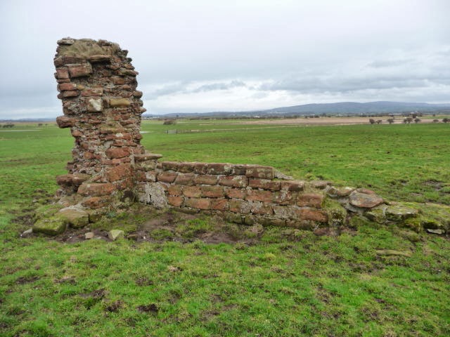
Cockersand Abbey is mostly a ruin, although the Chapter House still stands, the rest of the Abbey having fallen into wreck and ruin after the dissolution of the monasteries in the 16th century. It's a pretty bleak location in winter and, with the howling wind and the onset of rain, it felt desolate, as we slid our way past through a muddy field.
 |
| The Chapter House of Cockersand Abbey |
 |
| Cockersand Abbey ruins |
Cockersand Abbey to Glasson Dock (2 miles/3.2 kilometres)
I got a bit fixated by Plover Scar lighthouse, which is not far from the shore and marks the point where the River Lune meets the Irish Sea. We could also see the grim outline of Heysham Nuclear Power station on the far side of the Lune estuary. This walk reminded me a bit of another coastal walk we did three years ago in Rochester, Kent. From Plover Scar it's a short walk to Crook Farm, where we left the coast, turning inland along a muddy trail that eventually took us to the small riverside port of Glasson Dock.
 |
| Plover Scar lighthouse |
 |
| Crook Farm |
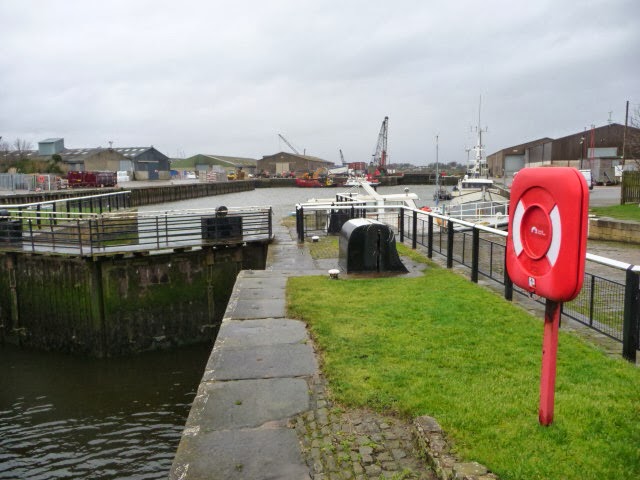 |
| Glasson Dock |
Glasson Dock to Aldcliffe Marsh (3.2 miles/5.2 kilometres)
We took a brief respite at Glasson Dock, sheltering behind the wall of the bowling green, as we nibbled on chocolate and listened to the wind whistling up the Lune estuary. From Glasson Dock to Aldcliffe Marsh it was a very easy and unremarkable walk along a disused railway line which used to link Glasson Dock with Lancaster and was run by the London and North Western Railway company. The remnants of the railway line are still visible. You can tell where the former platforms used to stand and you can almost hear the whisperings of past trains trundling alongside the river.
 |
| Disused railway line near Glasson Dock |
You can't quite see the Gothic buildings of Ashton Hall from the path, but you can see the golf course, which is managed by Lancaster Golf Club. After Ashton Hall the path passes under a line of electrical pylons, which run straight out of the nuclear facility. It was an eerie place and the wind caused a booming sound, as it thrashed its way through the steel framework of the transmission towers.
 |
| Transmission Towers from Heysham Banks |
Aldcliffe Marsh to Freeman's Wood (0.9 miles/1.4 kilometres)
At the beginning of Aldcliffe Marsh, the coastal path turns left down through the marsh, but this path was flooded, so we continued to follow the disused railway line, along a ridge of higher ground to an industrial estate, just past Freeman's wood.
 |
| BAM on the railway path near Aldcliffe Marsh |
We see a lot of curious things during our Chester walks, but the graffiti along the edge of Freeman's Wood was very curious indeed. According to the campaign website Friends of Freeman's Wood this woodland areas belongs to the common people of Lancaster and should remain a place where the public can enjoy the outdoors and should not be concreted over or sold off to private developers, as is currently planned. The struggle for Freeman's Wood is a very local one, but interesting and you can read a good summary of the issues on this blog post.
 |
| Protest graffiti in Freeman's Wood |
 |
| Sign with protest rhyme |
What struck us most was the rather haunting sign quoting the words of a 17th-century protest rhyme:
They hang the man and flog the woman,
That steals the goose from off the common,
But let the greater villain loose,
That steals the common from the goose
English people are, quite rightly, proud of their common land and rights of way - conflict with private developers is centuries old and it's interesting to see this still being played out in the 21st century.
Freeman's Wood to Lancaster Castle (1 mile/1.7 kilometres)
The industrial estate is mostly on the site of the abandoned Williamson's Factory - a major producer of linoleum in the late 19th century. Lancashire was famous for its cotton mills and, I guess, linoleum was an offshoot of textile manufacturing. Nowadays, this part of the city is full of new housing developments - these were partly constructed when we were there, but I'm pretty sure they will be completed and occupied by new house owners pretty soon.
 |
| Long Marsh Lane |
 |
| View of Lancaster from the castle |
 |
| Lancaster castle |
We finished our walk with a hearty meal in The Water Witch - an award-winning pub on the Lancaster canal side - before jumping on the train back to London.
Access for wheelchair users:
 |
| Disused railway paths are usually good for wheelchairing |
Image credits:
All photos were taken by me - please feel free to reuse them, under the Creative Commons license, with Attribution/Share Alike