Sunday, December 24, 2017

Cirencester - Christmas Trees, Hope and Heavy Rain

Flag of GloucestershireThe fact that I’m writing this blog post on Christmas Eve shows how busy life has been since we did our last Chester walk, more than a month ago, up in the wilds of the Gloucestershire/Wiltshire border.

There’s no train station in Cirencester (pronounced Siren-sester) which seems like a bit of an oversight, so we found ourselves jumping off the train at Kemble, late on a Friday evening, then catching a taxi from Kemble to Cirencester, a mere 12 minutes by car.

Lodgings and victuals

Cirencester
We stayed in the delightful Ivy House BnB, which is on Victoria Road in Cirencester. The BnB owners are just about to retire, so they may not be running Ivy House by the time you read this blog post. It was a bitterly cold night, but we ventured out for a night cap and found a warm welcome at The Bear Inn on Dyer Street, a bar which has loads of books, which made me happy - even if I didn’t have time to read any of the books, I still liked the idea of being surrounded by them.

Church of St John the Baptist to Upper Siddington (2.2 miles/3.5 kilometres)

We really liked Cirencester and I could think of worse places to live, even if, what had been forecast to be a sunny winter’s day turned into a bit of a washout and the rain had come on before we’d properly set out on our walk. We’ve visited many beautiful churches during our series of Chester walks, but I really loved Cirencester’s main church, St John the Baptist. It’s an interesting building, architecturally, and there was a really lovely feeling inside and lots going on, including a display of Christmas trees and a bookshop selling cards, as well as books.

Inside St John the Baptist church in Cirencester

Detail of church organ in Cirencester

Unusual Christmas tree decoration

Hard to believe nowadays, but Cirencester was once one of the most important settlements in Britain, during Roman times, right up there with Colchester and St Alban’s and there is an area of the town, known as the Querns, where you can see the remains of Cirencester's Roman life in the Cirencester Amphitheatre.

We faffed around quite a bit, trying to find a way into the Amphitheatre, walking as far as the roundabout on the Bristol Road, then wandering around Waitrose car park, before we headed along Sheep Street and over the bridge to Cotswold Avenue. The Amphitheatre today is a covered mound of grass and reminded me of the Maumbury Rings in Dorchester, although on a much larger scale.

Roman Amphitheatre at the Querns in Cirencester
The rain started coming on quite heavily, as we made our way through the Love Lane industrial estate, on the edge of Cirencester, towards the suburban village of Siddington.

Upper Siddington to South Cerney (2.8 miles/4.5 kilometres)

We didn't actually pass through Siddington village, but we could see it on the other side of the canal, as we followed the Thames and Severn Way in the direction of South Cerney.  We saw the Thames and Severn Way very briefly, when we were in Stroud last year for the Frocester and Woodchester walk and this is a handy path that, quite literally, links the Thames to the Severn, the Thames side starting in Lechlade, finishing on the Severn at a little village called Upper Framilode. It's 43 miles (69km) in total and follows the old Thames and Severn canal, formerly an important transport route for produce and people across the Cotswolds area.

Canal bridge at Siddington
It took a while to figure out what the symbol of the Thames and Severn Way represents - at first, we thought it might be a train passing through a tunnel, until we realised, it represents a canal boat sailing under a bridge.  It made for pleasant walking and I was quite pleased to find that the ominously named Cowground Bridge didn't have any cows underneath it, just some dog-walkers, bravely bracing the elements.

Symbol of the Thames and Severn Way
We left the Thames and Severn Way just outside South Cerney, as we turned down Northmoor Lane, much to BAM's horror, as it meant walking on the roadside into oncoming traffic (BAM's idea of hell!) It didn't take very long though until we got to the end of Northmoor Lane and turned left into the village.

BAM walking towards South Cerney
South Cerney to Ashton Keynes (2.5 miles/4 kilometres)

We had a short break in South Cerney, sheltering from the rain in the porch of All Hallows church.  South Cerney gets its name, as Cirencester does, from the River Churn, a great name for a river if ever I heard one! It certainly felt like we were churning through the mud and rain on as wet a November day as one could hope to experience.

All Hallows church in South Cerney
Interestingly, the noticeboard at the church had the word Hope in different fonts and it got us thinking about the world we live in today and how important Hope is to people - hope that we won't completely destroy the environment, hope that we won't kill each other in a nuclear war, hope that the next US President might be someone to feel hopeful about!

Noticeboard at All Hallows Church, South Cerney
With hope in our hearts, we continued our walk, passing through beautiful old buildings in South Cerney, having a giggle at the curiously named Bow Wow Lane before turning onto Broadway Lane. Halfway down Broadway Lane, we turned onto a very narrow path between a residential area and an industrial estate, before coming out into the Cotswold Water park and making our way on to the village of Ashton Keynes.

Narrow path off Broadway Lane in South Cerney
Ashton Keynes to Kemble (5.9 miles/9.5 kilometres)

We've been in Ashton Keynes before and, actually, the rest of this walk we'd already done in the opposite direction, when we walked the Thames Path a few years ago. As we left Ashton Keynes, the rain got even heavier and the light was quite dim on this last part of our walk.


Ashton Keynes (Wiltshire)

There weren't many people around, so it felt like we had the countryside all to ourselves. It got dark just as we reached the road into Kemble and, by the time we got there, we were soaked through. We were pretty happy to reach The Tavern Inn near Kemble station, where we changed into our jeans and soft shoes, then dried off a bit, before getting the train back to London.

Thames path near Kemble


Access for Wheelchair Users

Unfortunately, not much of this walk would really be accessible to wheelchair users, although it would be possible to get to the Amphitheatre in Cirencester and wheelchair around there.  In our experience, the roads around this part of Gloucestershire are quite busy, with no footpaths and, therefore, dangerous for wheelchairing.  There's a nice path through the Cotswolds Water Park though that seemed pretty accessible.  

Image credits:

All photos were taken by me - please feel free to reuse them under the following Creative Commons license:

Attribution (especially to this blog post)
Share-alike

Non-commercial

Friday, September 29, 2017

Gloucester - Bus times, Broadband and the story of Bill's

It's been just over a year since we had our first foray into Gloucestershire, when we walked in the Cotswolds last June (visiting Frocester and Woodchester).  But this was our first visit ever to Gloucester city itself.

In Roman times, Gloucester was called Colonia Nervia Glevensium or Glevum for short.  The origin of this name is a bit obscure, but it might come from a Celtic word for 'bright place' (sounds suspiciously like the Germanic word glow - which makes me think there may have been some obfuscation of the meaning down through the years).

Glevum - the Roman name for Gloucester
Interestingly, the modern Welsh name for Gloucester is Caerloyw and the modern English name is what's left of Gleaw + chester.  It's one of the English place names I really struggled to pronounce, when I first visited this country - for anyone who's still a bit unsure, it's generally pronounced Gloster.

The Museum of Gloucester on Brunswick Road
Lodgings and victuals

It wasn't very bright when we arrived off the train around 9pm on a Friday evening in August and it was difficult to get a sense of the place, as we made our way along Brunswick Road towards the Travelodge, our destination for the evening.  We managed to have a half-decent meal at The Lord High Constable of England in Gloucester Quays, run by the Wetherspoons chain and the pub was packed with the Friday night crowd - a friendly buzz of conversation, laughter and background music.

Gloucester Quays - the place to be on Friday nights!
Gloucester Quays is probably the most attractive part of town and there is a good selection of restaurants and bars in converted customs buildings near the River Severn.  Not to mention a Saturday morning market and an artificial beach beside the quays, which intended to save people the long journey to the coast!

The artificial beach on Gloucester Quays

We decided to have breakfast in Bill's Gloucester Quays, which was nothing less than sensational! Purely by coincidence, I had been in the original Bill's in Lewes the week before and I'm quite interested in Bill's story and how this restaurant chain has become so successful - not to mention the fact that their food is amazing!

Breakfast at Bill's in Gloucester Quays
BAM (Best Aussie Mate) was convinced that Bill's is, in fact, an Aussie chain, but a quick search on Google cleared up the confusion, as we learned that there is another chain of Bills, which has also has a story and started in Sydney, Australia.  By all accounts, the food there is also very good and I'm sure some of our Australian readers will be able to confirm this.

Mitcheldean to May Hill (3.3 miles/5.3 kilometres)

We decided to start in the country and walk back to Gloucester, both for the satisfaction of having a sense of destination, but also for the convenience of being able to jump on a train afterward, for the journey back to London.

Getting to Mitcheldean was a bit of an adventure though - unfortunately, the bus times from Gloucester to Mitcheldean have changed recently, but the website I was looking at hadn't been updated, so we missed our bus by about five minutes and ended up catching a taxi to Mitcheldean instead.

Mitcheldean in Gloucestershire
Thirty minutes and £27 later found us on Hawker Hill in Mitcheldean, looking for the Wysis Way, which is the path we followed for most of this walk.  Mitcheldean appealed to me, as Mitchel is another way of saying Michael and, indeed, the main church in the village is called St Michael's.
I don't think we'd walked on the Wysis Way before and it's a handy 55-mile link between the Offa's Dyke path and the Thames Way.

As we left Mitcheldean on a small road which passed the Business Village, we had an interesting debate on the responsibility of governments to provide decent broadband and I was trying to convince BAM that we're living in a first-world economy with third-world Internet connections.

View from May Hill Farm
I'd read recently that the UK's connectivity is worse than Romania's, but actually, researching this further, I've learned that this isn't true and, actually, both the UK and Romania have strong Internet connections - about 16.1 mbps in Romania and 16.3 in UK.  There is an organisation called Akamai that publishes quarterly reports on the State of the Internet - well worth a look, if you're interested.

The highlight of the walk was reaching the top of May Hill, not the biggest hill in the world, at 296 metres, but with fantastic views across to the Wye Valley and the distant hills of Wales to the West, as well as a stunning view of the River Severn, wending its way to the south.  I'd like to return to May Hill on May 1st, as apparently they have Morris dancing on top of the hill every year!

May Hill - view towards Wales

May Hill - old signpost

Trig on the top of May Hill
May Hill to Tibberton (4.8 miles/7.7 kilometres)

From May Hill, it was an easy path down towards May Hill village, then a very quiet path through Newent Woods, where we met a rather rugged man, who was carrying a sawn-off piece of tree.  We stopped to talk to him and he showed us the rings on the bark, which he was going to use to calculate the age of the tree.

There is a rather lovely-looking pub at Glasshouses called The Glasshouse Inn, after which we followed the least well-marked section of the entire walk, through Castle Hill Wood, past a small lake hidden in the depths of the Gloucestershire jungle!

The Glasshouse Inn
After Byford's Farm, I had to face my worst fear again with a field-full of young cows, who seemed rather panicky at the sight of us.  We passed through a total of four fields full of cows on this walk and I think I'm starting to come to terms with the fact that if I don't panic, they are also less likely to panic.  Animals can smell fear and stress and they don't respond well to that, so I kept my breath calm, as we slowly made our way past the various herds of cows we met on the Wysis Way.  Still not my favourite thing though and the thought of cows fills me with dread!

It's hard to write this in September and realise how hot the weather was, just over a month ago but, by the time we got to Tibberton, I was starting to feel a bit dehydrated, so it was lovely to sit in the churchyard at Tibberton Court and have a little rest , about halfway through the walk.

BAM negotiating the fields around Tibberton

Holy Trinity Church at Tibberton
Tibberton to Lassington (3 miles/4.8 kilometres)

I have to say, the people of Tibberton weren't particularly welcoming, especially when we missed the signpost for the Wysis Way in Orchard Rise and got told off by a rather obese lady, who had been enjoying the sunshine in her back garden, until we appeared on a lane between houses, trying to get back onto the path again.

After Tibberton the path disappeared completely into a field of crop and we almost got scratched to death making our way to an eerie cluster of buildings called Bovone, the kind of place that looks like it could feature in an American movie about serial killers!

At Bridge Farm, we crossed the road and joined a disused railway track, which is now part of the Three Choirs Way - a path we walked on before, when we were visiting Worcester back in 2012.  It was an easy path and not too many cows between Bridge Farm and the medieval village of Lassington.

Disused railway line, now part of the Three Choirs Way
Lassington to Gloucester (3.5 miles/5.6 kilometres)

There is nice view of Gloucester and the Severn Valley from the north side of Lassington Hill, then a complicated route downhill through a small wood and out onto the main road at Over.  From Over, we followed local footpaths all the way the Gloucester.

Train near Over

By the time we got to Gloucester, my tongue was stuck to the roof of my mouth, so I was really happy to have a cold beer and some food in the garden of the lovely Fountain Inn just off Westgate Street.

Street Art in Gloucester
Access for Wheelchair Users
Field edge near Taynton

Very little of this walk would be recommended to wheelchair users - but there are plenty of interesting and accessible paths around Gloucester.  I would also recommend a return trip to May Hill from Glasshouses, all of which could be done by using small roads.  

There is a small road that runs from Glasshouses to Tibberton, pretty much parallel with the Wysis Way, but you should only use roads at your own risk and I couldn't really recommend this.  

Image credits:

All images were taken by me - please feel free to reuse them under the Creative commons license:

Attribution (especially to this blog)
Share alike
Non-commercial

Sunday, July 9, 2017

Carmarthen - Cats, Cows and Castles

Carmarthen marked our second foray into Wales, as part of our series of 'Chester' walks and the weather couldn't have been more different on this walk (blazing hot sunshine) compared to our last Welsh walk, from Caerphilly to Cardiff, back in February (a lot less sunny!)

I'm very fond of Wales - there are more castles than you can shake a leek at, the countryside is beautiful and it reminds me a little bit of home (Ireland). I'd previously been to Swansea, many years ago, for a work conference and my memories of this part of Wales included the impressive steelworks at Port Talbot and the industrial slag heaps outside my hotel window!

BAM (Best Aussie Mate) knows South West Wales very well, due to her kayaking trips, but it was my first time west of Swansea and, with the glorious June weather and the unspoilt beaches along the Carmarthenshire coast, it certainly left a good impression on me!

Lodging and victuals

Carmarthen is believed to be the oldest town in Wales and was one of the most far-flung reaches of the Roman Empire.  It's also one the most far-flung Chesters on our list, so we both took the Friday off work, so we could enjoy the three and a half hour train journey from London to Cardiff to Swansea to Carmarthen and then back a little bit to Kidwelly, where we'd resolved to stay the night.

Kidwelly is a small town with a huge castle and a pleasant enough place to spend the evening.  We stayed at the lovely Kidwelly B&B on Causeway Street, where we were made very welcome by the proprietor, Gerri Tennant, who moved to Kidwelly from the West Midlands.

Kidwelly, Carmarthenshire

Kidwelly castle

There weren't too many options for dinner, apart from Chinese takeaways, so we booked into The White, which was so-so - not the best meal I've ever had, but enough to fill us up for the evening.  After dinner we took a walk around the village and visited the castle.  Like many castles in south Wales, it was built by the Normans, in their attempt to contain the rebellious native Celts and bring Wales under their control.

Interestingly, the name Kidwelly, which used to be spelt Cetgueli in English, led to a legend about a black cat, which people believed was the source of the town's name.  A black cat features on the town's coat of arms and, as if to prove its importance, we even met a black cat, who was sitting in the middle of the road, just outside the castle, licking himself, as cats know how to do best!


Kidwelly to Llansaint (2.2 miles/3.5 kilometres)

You can now walk the entire coast of Wales as, in 2012, Wales became the first country in the world to open a long-distance footpath (870 miles) that is on/near the country's coastline.  Our entire route was following the Wales Coast path, although we didn't actually spend a lot of time on the coast, as Kidwelly sits at a point where the River Towey flows into Carmarthen from the sea and this particular section of the coast path is mostly inland.

View towards the Gower peninsula


By Hogyn Lleol - Own work,
CC BY-SA 3.0,
We loved the coast path logo, a sort of hybrid between a dragon and a seashell and, as we set out along the path from Kidwelly, we had great views towards the Gower peninsula and the Irish Sea, in the distance.  The path leaves Kidwelly following the Gwendraeth river, where we saw the most athletic cow I've ever seen, jogging along the river bank!  The path soon led to a rather busy country road, which runs between Kidwelly and Penallt, then we turned uphill along a rough track towards a hilltop village called Llansaint.

Llan is a common prefix in Welsh place names and it means saint - so I was a bit surprised to find myself in Saint saint!  The village was previously called Halkenchurche, which means 'Church of Saints' - so the Welsh name continues that translation.  It's a pretty village and the only other living soul in Llansaint was the postman, who we bumped into several times, as he was making his rounds of the village.  I always wanted to be a postman, when I was a child, but I don't drive, so not sure I have the right skill-set for a change of career at this point in my life!  You could do worse though, than drive around Carmarthenshire delivering the mail?

The white church at Llansaint

Llansaint to Ferryside (2.3 miles/3.7 kilometres)

There are some nice little forested valleys on this route that make you feel as though you are miles from anywhere - it was also a bit of a relief to get out of the sun occasionally, although these little shaded valleys suddenly became quite jungle-like in their midday humidity!

Before long we came to a rather interesting collection of buildings at Pengay Farm, on a small hill overlooking the sea.  The farm was the seat of the Bevan family (relation of the famous Bevan brothers who set up the NHS?) and the family has a strong Methodist tradition, that is common in this part of Wales.  The farm buildings are from the 18th century and there was a rather welcome bench in the middle of the farm, which was in the shade of some trees, so we stopped for a water and chocolate break.

Pengay Farm, seat of the Bevan family
From the farm it's an easy mile or so downhill towards Ferryside, a holiday village dominated by the railway line that runs from Carmarthen to Llanelli.  On the way down, we had great views across to a ruined castle on the hill above the village of Llansteffan, on the other side of the Towey river.

View towards Ferryside and Llansteffan

Rocks at Ferryside


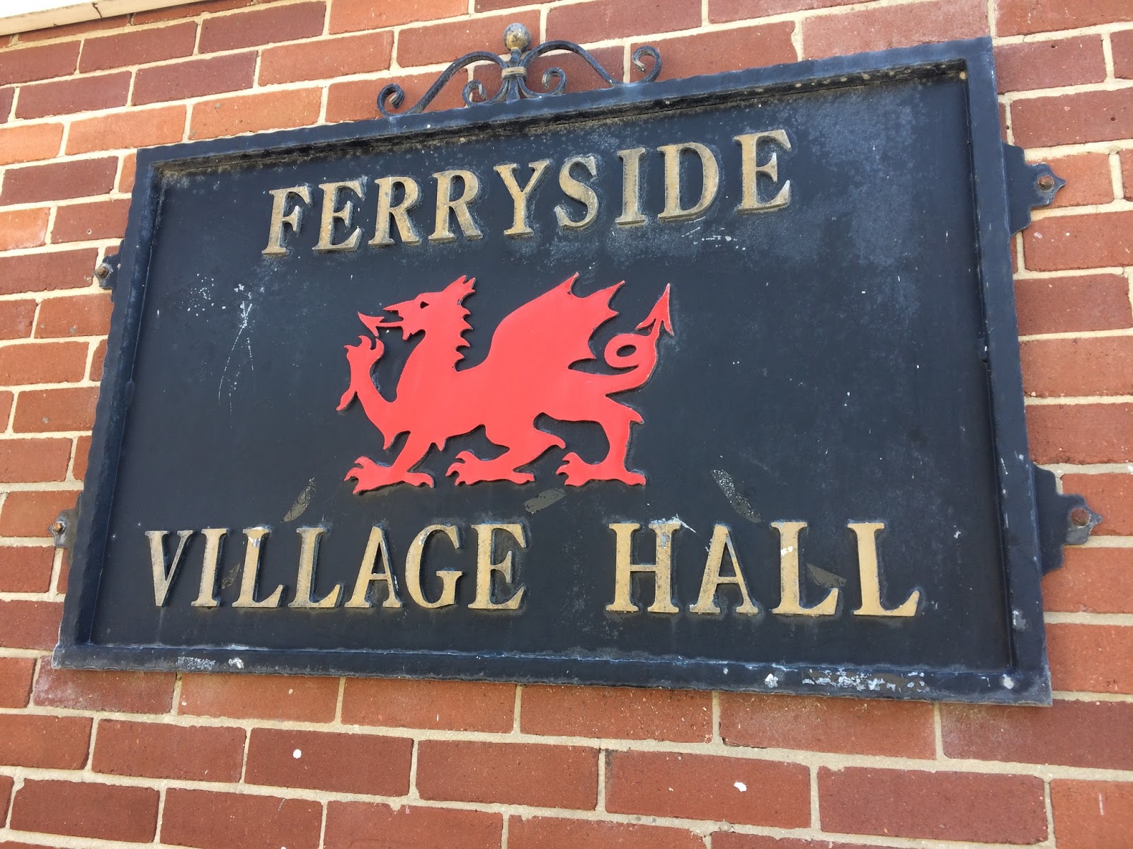
Ferryside to Bronyn Farm (1.4 miles/2.3 kilometres)

After a much needed refreshment in Ferryside, we set off along the Carmarthen Road, before turning into a laneway past the curiously-named hamlet of Rotten Pill, then we followed the railway line through a steep valley leading to Bronyn Farm.

Ferryside Village Hall
Whilst a lot of farmers and land-owners have insisted that the coast path be routed away from their land, the couple who own Bronyn Farm seemed to have embraced the public right of way and gave us cheery waves, as we walked through their farm on the way to a small country lane on the far side of their land.

As we closed the gate to their farm, a train sped past and, as we knew that BRH (Best Russian Husband) was on his way to Carmarthen at some point that afternoon, we waved at the train in true-Railway children style, hoping he would look out of the window and see us (it turns out his train was arriving a few hours later than we thought, but it amuses me to think of passengers on the train seeing us and wondering who had let the lunatics out of the asylum for the day!)

Bronyn Farm to Gellylednais (2.6 miles/4.2 kilometres)

From Bronyn Farm we followed a series of country lanes, climbing uphill again until we got to the top of Trelymsi, where we were rewarded with lovely views towards Llansteffan and the outskirts of Carmarthen, barely visible in the far distance.

Country lane at Trelymsi

The hedgerows were absolutely full of verdant plant growth and flowers, lots of foxgloves on this walk, which really took me back to my childhood, when we use to pull the flowers off the foxgloves and wear them on our fingers!  BAM also identified red campion, crane's bill, dandelions, buttercups, dog rose, daisies, bramble, cow parsley, honeysuckle, knapweed, bindweed, red and white clover and even fuchsia, which lit up the roadside in a splendid roadside red.

We passed another farm at Pentrecwm, where a pack of dogs were rather excited by our arrival and barked furiously, whilst keeping their distance.  After the farm itself, we entered my worst nightmare - a field full of cows (or this time, young bullocks).  I feel I've come a long way, since my being-chased-by-cows experience in Uttoxeter in 2014 and, after a momentary panic where I thought 'I can't do this' - I quickly regained my composure and followed BAM, as she bravely struck out across the field.

We saw some more peaceful-looking cows later in the walk
There were cows running in every direction around us, some were quite panicked, others were trying to sneak up behind us, but BAM chased them off every time they got too close.  It was a relief to get through the field, although the far side was downhill, which meant that the cows were on higher ground than us, which also frightens me, but we eventually found a gate leading to another wooded valley.

Passing down and up the side of the valley, we came to another field, where a large white horse was blocking the kissing-gate we needed to pass through.  It was clear that the horse was very ill, as he was breathing heavily and had some foam in his mouth, as well as some half-chewed grass. I thought he might be dehydrated, as he seemed to be staring longingly at the small stream that was trickling past on the other side of the fence from him.

We managed to coax him away from the gate, eventually, and crossed the field quickly, to see if we could find a farmer, or someone who might be able to check that the horse was okay.  Unfortunately, the only people around were holiday-makers, but we passed on the information to anyone we could find within a mile radius, to see if they could get some help.

Gellylednais to Carmarthen (4.6 miles/7.4 kilometres)

After Gellylednais we came to Towey Castle Farm and Towey Castle, where there is a residential home, where a small dog accompanied us on part of the walk.  We bumped into the only other walkers we met that day in a field just outside Towey Castle and gave them an estimation of how much time it would take for them to walk to Ferryside.  I think they were originally planning to go to Kidwelly but, as it was already well into the afternoon and they looked quite tired, I doubt they made it all the way to Kidwelly.

Small town life in Croesyceiliog
Not long after that we came to a small road, which led to a bigger road that runs through Croesyceiliog and another few miles to Pen-sarn, then through some industrial estates and concrete underpasses until we emerged at Carmarthen train station and crossed the bridge to visit the town and the remains of the Carmarthen castle.

Carmarthen
Carmarthen castle
We thought it was quite amusing to see sheep grazing, a stone's throw from the town centre and we really liked Carmarthen - there was a nice atmosphere in town, although all the shops had closed, we grabbed a bit to eat at Pizza Express, overlooking a small square in the shopping district.

Access for Wheelchair users

A lot of this walk went through fields and along small walking paths, so the walk in its entirety wouldn't be suitable for wheelchair users, however, there were many parts of the walk that followed quiet country lanes and the sections around Llansaint and from Towey Castle into Carmarthen could be adapted to suit a wheelchair user.  

Of course, it's always dangerous to wheelchair on roads, so you should only do so, if you're willing to deal with oncoming traffic.  

Image credits:  

All photos were taken by me - please feel free to reuse them under the following Creative Commons license:

Attribution (especially to this blog post)

Share-alike

Non-commercial