Sunday, November 13, 2016

Chesterblade - Sheep, Steam Engines and Squaddies

Almost a month has passed since we set off on our weekend adventure to Somerset, in pursuit of yet another Chester, this time Chesterblade, a hamlet just a few miles south of Shepton Mallet, the main town in the Mendip hills.

This was our second trip to Somerset, having visited the more famous Roman settlement of Ilchester in April 2014.  As with our last trip to Somerset, it was more convenient to get the bus than the train, so we found ourselves at Hammersmith bus station, after work on Friday evening, queuing up eagerly for Berry's coaches and our great journey to the West!

We've become very fond of Berry's coaches - the staff are really friendly and the bus driver kept us entertained as we trundled through the dark and barren landscape of Salisbury Plain.  We arrived in Shepton Mallet around 9pm and then followed the High Street towards the busy Bath Road and our accommodation at Mendip Lodge campsite.

Shepton Mallet High Street


Lodgings and victuals

I've stayed in yurts before, when I travelled to Mongolia in 2015, so I was quite excited to stay in a yurt again, but this time in England.  Mendip Lodge campsite was very quiet, because of the time of year, so there weren't actually any campers (quite cold to be in a tent).  We had some difficulty finding it in the dark, but the friendly owner, Maureen, guided us by phone until we found the entrance to the farm and our lodging for the night.

Candlelit lanterns at the yurt in Shepton Mallet
Maureen's husband Colin had prepared a fire in the yurt's stove, so it was very cosy when we arrived and the yurt looked absolutely magical in the flickering candle light.  We didn't have any victuals, as such, as we'd both eaten earlier, but we shared a bottle of wine and caught up on our respective lives, before preparing our beds and settling in for a good night's sleep.

Shepton Mallet inside the yurt
We absolutely loved the yurt, although it's by a busy road, so not as tranquil as we imagined it would be.  Yet, waking up in the morning, with late autumn sunlight streaming through the top 'window', then preparing breakfast in the nearby kitchen - it was a great adventure and brought us close to nature, whilst maintaining a level of comfort that is important at this time of the year!

Shepton Mallet yurt
Mendip Lodge campsite to Newman Street Farm (2.6 miles/4.2 kilometres)

We set out on our walk directly from the campsite - picking up a public footpath that brought us into a field which had some cows, lurking menacingly in the distance.  Rather than engage with the cows, we followed the footpath to Yellingmill Lane, then followed this lane way until it met up with Bolter's Lane.  We could see Beacon Hill and the Mendips, not far to the north, but we turned off Bolter's Lane at the curiously named Wagon and Horses Hill, before following the King's Road and then turning off on a track leading to Newman Street Farm.

Farmhouse near Shepton Mallet
Our path crossed the Fosse Way, a major Roman road from Exeter to Lincoln and one we've met, not only in Ilchester, but also in Leicester, when we walked there precisely four years ago.  The name fosse comes from the Roman word for ditch and it is little more than a track now, so it was barely noticeable, as we focused on the route I'd mapped out on my Ordnance Survey app.

Somerset countryside
As we walked, we talked about the recent visit of BAM (Best Aussie Mate)'s relatives from Australia and how wonderful it was to spend time with them.  Australia seemed like a very long way away, as we turned down the King's Road, with a picturesque corner of Somerset spread out in front of us and grey clouds scuttling overhead.

Sign post for East Mendip way
Newman Street Farm to Cranmore (3 miles/4.8 kilometres)

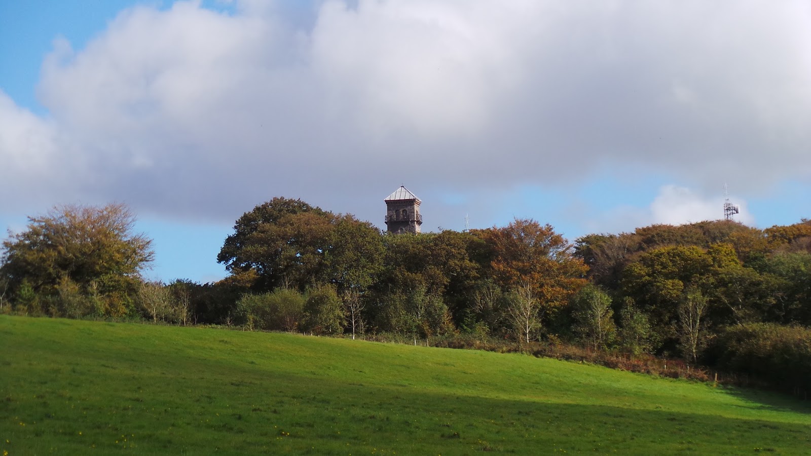
At Newman Street Farm we picked up the eastern part of the Mendip Way, a 50-mile walk from Weston-super-Mare to Frome.  We spoke briefly with a very friendly farmer at Temple House Farm, who pointed us in the right direction and we crossed a small lane and headed up along a slight incline in the direction of Cranmore Tower, a 19th-century folly, that was built on the site of a Roman settlement.

View towards Cranmore Tower

We didn't actually make it to the tower, as our path turned downhill again, along Dallimore Lane (more of a ditch really) to reach the houses at Dean, on the busy A361 road, the longest three-digit A road in the country.  As I have my fear of cows, so BAM has her fear of walking along busy roads, so it took a little bit of persuasion to get her to follow the A361 for 50 metres, until we picked up another public footpath on the far side of the road, which led us over a small hill, through a field, until we reached the village of Cranmore.

Walking towards Cranmore
Cranmore to Chesterblade (1.7 miles/2.7 kilometres)

We had a rather pleasant lunch in the churchyard of St Bartholomew's at Cranmore.  The name Cranmore means 'crane lake'.  We didn't see any cranes as we ate our lunch, but we could hear the huffing and puffing of the East Somerset steam railway, not far from the church.  By the time we'd finished our lunch and made it to Cranmore Station, the steam engine had vanished, like an illusion and we were left standing on the bridge, peering into the distance and wondering whether or not it had all been a figment of our imaginations, or a ghostly echo of times past.

St Bartholomew's Church in Cranmore
Cranmore railway station
From Cranmore, we followed the country lanes to Chesterblade and had another quick break in the churchyard of St Mary's Church, a very still and tranquil place that has a long history stretching back to the 12th century.

St Mary's Church in Chesterblade
Tree in churchyard of St Mary's Chesterblade
Chesterblade is one of the smallest Chesters we've ever visited and it seemed like a pleasant enough place, although there wasn't much going on there.

Commandment on Church wall in Chesterblade
Sign post for Evercreech
Chesterblade to Chelynch (3.2 miles/5.1 kilometres)

From St Mary's Church, we headed downhill along the Chesterblade Road, in the direction of Evercreech.  Less than a half a mile down the road, we reached the floor of a very small valley, where we looked for an ill-defined public footpath, taking us through some wildly overgrown fields until we reached Holcombe Farm and Holcombe Lane.

Countryside near Chesterblade
As we followed Holcombe Lane, across Brottens Road and under the railway bridge along Merryfield Lane, I told BAM all about my latest writing project.  We paused all conversation, as we carefully crossed the A361 again and made our way to Chelynch village.

Chelynch to Shepton Mallet (2.4 miles/3.9 kilometres)

At Chelynch, we picked up the Mendip Way again and followed this all the way back to Shepton Mallet, over Ingsdons Hill, where we could see Glastonbury Tor in the distance.  Not surprisingly, given its name, Shepton Mallet was famous for its wool industry, although we didn't see any sheep on our walk, just another herd of cows, who huddled in the corner of their field and looked at us wearily, as the rain came on.

View towards Glastonbury Tor
By the time we got to the railway viaduct at Shepton Mallet, it was raining heavily and we were keen to get back to our yurt and into some dry clothes before heading out for dinner. Someone stopped us in the street in Shepton Mallet to have a chat about life, travel and Northern Ireland, which would have been lovely, except for the fact he was quite drunk and it was raining heavily.

BAM walking towards Shepton Mallet
We also saw three rather drunken squaddies, getting soaked, as they were wearing only T-Shirts, but happily singing their way through a damp late afternoon, as they queued at the Co-op ATM, getting more money out to continue their revelry.

Myself and BAM had a rather less raucous, but arguably more pleasant evening, stuffing ourselves at Blostin's - a slightly expensive, but endearing restaurant on Waterloo Road.

115 miles to London
Access for wheelchair users
Sign post for Batcombe

The country roads and lanes around Shepton Mallet are fairly traffic-free, but this walk, in its entirety, would not be practical for a wheelchair user.  Probably the most interesting route for a wheelchair user would be from Chesterblade to Evercreech, then along Holcombe Lane and Merryfield Lane to Chelynch, although crossing the A361 might be a bit of a challenge.  

Image credits:

All photos were taken by me - please feel free to reuse them under the following Creative Commons license:

Attribution (especially to this blog post)
Share-alike
Non-commercial

Saturday, September 10, 2016

Grantchester - Academics, Apples and sore Ankles

As Cambridgeshire is so close to London, we decided to do our Grantchester walk as a day trip, travelling from Liverpool Street station to Cambridge early on Saturday morning, returning from Great Shelford station later in the evening.

I'd been in Cambridge quite a few times before, always work-related and it's a place I struggle to understand - a completely different world from the one I live in. A world of academia and bicycles, college dons and big ideas.

I guess it's only the privileged few who get to study in Cambridge, it was never really an option that presented itself to me when I was a young buck, growing up in a working-class community in Donegal.

The allure of this other world has certainly worked its magic, judging by the hoards of tourists that were clogging up the city on the Saturday morning in August (last month) when we did this walk.  I found it quite overwhelming actually, as myself and BAM (Best Aussie mate) used our walking poles as weapons, to carve our path through the crowded streets.

Cambridge station to Scudamore's Mill (2.6 miles/4.3 kilometres)

We set off along Station Road, then turned right along Hills Road, our initial destination being a diamond-shaped park called Parker's Piece.  It's a curious name for a park and the land that the park is on once belonged to Trinity College, Cambridge but was sold to a man called Parker, which is where the name comes from.  It's the place where the rules for Association football (the Cambridge rules) were formulated in the late 19th century.


From Parker's Piece, we made our way past Christ's College and along Market Street to Market Hill, where the Guildhall is, as well as Great St Mary's Church. We then made our way to King's Parade, past the impressive buildings of King's College and we ducked into King's Lane, which was a lot quieter than the main streets and followed Queen's Lane until we came to Scudamore's Mill and the punting station, where we were met again by crowds of people.


Scudamore's Mill to Grantchester (1.6 miles/2.7 kilometres)

I must admit, there is something very romantic about punting and I can see the attraction, although I'm not as fond of the water as BAM is, and I feel more comfortable walking along the river bank than punting down the river.  We were following a really well-trodden route at this point and it's been a bit of a fashion, since the days of Rupert Brooke, to hire a punt at Cambridge and make your way down the river for a lazy picnic at Grantchester.


I became a bit obsessed with Rupert Brooke when I first discovered his poetry at university - he was such a handsome man - and I once knew his poem The Soldier pretty much by heart.  An unusual thing for an Irishman, admittedly, but I think my obsession with English literature, the poems of Rupert Brooke and the novels of Thomas Hardy, with their magnificent descriptions of the English countryside, were a kind of rebellion to my Irish nationalist upbringing!

My older self reads The Soldier with a great deal of scepticism - I find it hard to enjoy the patriotism in the poem, the colonial heartbeat of the theme and the glorification of dying for your country.  I don't believe any of that, although I do still find Rupert Brooke interesting and I'd love to learn more about his life.

His grave, that piece of foreign land that is forever England, is on the Greek island of Skyros, not far from Evia, where I once spent a holiday.  As we walked along the River Cam, on our way to Grantchester, I thought that Rupert Brooke must be turning in his grave to know that the elegant tradition of punting has been taken over by raucous groups of privileged youth, destroying the tranquillity of the countryside by shouting and screaming with laughter, getting rat-arsed in the afternoon sun!

Like Puritans from a bygone era, myself and BAM had lunch on the river bank near Grantchester, tutting and shaking our heads in disbelief, as groups of lager louts punted by, in increasingly dangerous zig-zags, as they tried to navigate the narrow bends in the river.  


Grantchester to Haslingfield (2.7 miles/4 kilometres)

We had another stop at the Orchard tea room in Grantchester, a wonderful place to sit and enjoy a mid-afternoon cup of tea or a snack.  Rupert Brooke once lived at Orchard House and started a trend that was followed by notable writers like Virginia Woolf and E.M. Forster, as well as philosophers like Bertrand Russell and Ludwig Wittgenstein.  Not to mention the familiar hoards of tourists, who somehow managed to transport themselves from Cambridge in the morning to Grantchester in the afternoon.


This was the first Chester walk where we abandoned my paper map and did the whole thing solely through the Ordnance Survey app.  BAM bought me a year's subscription to Ordnance Survey a few years ago, but the technology was difficult to use back then and not very accessible on a mobile platform.  Since then, they've really upped their game.  I have used the app on many walks recently, including trickier ones in the New Forest and it's been very reliable.

Not that it was difficult to find our way out of Grantchester and it was a very straight forward couple of miles along a walking path crossing the M11 and then following the curiously named 'Cantelupe Road' leading to the village of Haslingfield.


The M11 is quite a short motorway, just 56 miles from London to an obscure point near St Neot's, a place we've also visited on our Chester series.  We don't believe that Cantelupe Road was named after the melon, but it's possibly named after the Viscounts Cantelupe (later Earls of De La Warr), Vita Sackville-West's ancestors, who seem to have an historic link to Cambridge.


There is also an English saint called Thomas de Cantilupe, so perhaps the road is named after him? Interestingly, St Thomas de Cantilupe died in the Papal States in Italy, not far from the village of Cantalupo in Sabina, which is where the melon takes its name from, although this melon species originates in Armenia.  Cantaloupe means 'song of the wolf', but we didn't hear any wolves singing in Cambridgeshire, a long way from the hills of Lazio or Armenia!


Haslingfield to Great Shelford (4.2 miles/6.8 kilometres)

It was also quite a straight forward walk from Halsingfield to St Edmund's Church in Hauxton, however, as well as switching to new digital technologies, I've also been breaking in a new pair of walking boots and, by the time we stopped for a break at St Edmund's Church, my poor ankles were throbbing and I was in a bit of pain!


I always hate changing walking boots and my new pair are the third pair that I've had.  My first ever pair of walking boots literally fell of my feet on the coastal path in Cornwall and my second pair seemed to be going to the same way, until BAM and other concerned friends staged an 'intervention' and convinced me to give them up finally.

From Hauxton we walked past a rather eerie abandoned mill, which used to be a traditional water mill, but lost its wheel a few years back. It would be a beautiful building, if it was refurbished and it definitely presents a good opportunity for creating a living or office space. It's a shame to see such a lovely building fall to wrack and ruin and I hope that someone does something with it before it falls down altogether.


After Hauxton Mill, we entered private land, which used to require written permission from the landowner, to cross his fields towards Great Shelford.  He must have got fed up with responding to letters from walkers, as he's now set up a permissive path through his land and I hobbled onwards, each step more painful than the last until we reached St Mary's Church in Great Shelford.


Great Shelford is more like St Neot's than Cambridge and our eating options were pretty limited, but we had decent enough fare at The Plough, amusing ourselves by watching a rather overweight cat dodge the traffic, as he crossed the High Street. It was a short hobble from The Plough to the train station, where we caught our train back to London.


Access for Wheelchair users:


There are plenty of accessible routes around Cambridge and, if you can deal with the crowds in summer, it would be a pleasant place to have a wheelchair accessible holiday.  The path from Cambridge to Grantchester and over the M11 is completely inaccessible.  

Cantelupe Road is a pleasant and accessible lane way, but it's very short. Unfortunately the rest of the walk, from Haslingfield to Great Shelford is also completely inaccessible for wheelchair users.  

Friday, June 17, 2016

Frocester and Woodchester - Tourists, Trees and Traffic

Although Frocester and Woodchester were our 38th and 39th 'Chesters', this was a walk with quite a few firsts for us - first time in Gloucestershire, first time in Cotswolds (for me, although BAM - Best Aussie Mate - had been in the Cotswolds before), first time camping on one of our Chester trips.

I've been quite busy with work recently, flying backwards and forwards between Europe, the Middle East and India, so it was with no small degree of culture shock that I found myself standing in a soft drizzle on Tinkley Lane, just outside Nympsfield, watching our taxi disappear in the distance on its return journey to Stroud, many miles away from the Corniche in Doha or the dusty streets of Gurgaon!

Lodgings and Victuals

I really loved camping on this trip, despite the heavy downpours of rain. Thistledown Farm campsite is a truly wonderful place, as far away from the stresses of modern life as you can hope to get these days.  It's a two-night minimum stay in the summer period, but I wouldn't want to have spent less than two nights there - in fact, I could have stayed a whole lot longer and enjoyed the serenity of the surrounding countryside, miles from the nearest towns or cities.

Campsite at Thistledown Farm
I'd had a serious case of 'Delhi belly' towards the end of my work trip to India, so my 'victuals' this time around consisted of a very plain ham and cheese roll from Upper Crust.  BAM had kindly brought a bottle of red wine, which we shared, sitting outside our tents, gossiping about recent events and questioning the meaning of life!

Thistledown Farm campsite to Frocester (2.8 miles/4.5 kilometres)

Our walk started off innocently enough - we had breakfast in the porch of my tent, sheltering from a heavy downpour of rain, then we got kitted up with our rain gear, as we carefully zipped up our tent flaps and set off along Tinkley Lane towards the nearby village of Nympsfield.

From Nympsfield, we followed a public footpath along the edge of a field, crossing the B4066 at Crawley Hill and picked up the national way-marked trail, the Cotswold Way.

View from the Cotswold Way
I'm quite interested in walking the Cotswold Way sometime, as it's a very convenient 102-mile path from Bath to Chipping Campden - so a handy week's walking holiday.  This was my first time on the trail and I wasn't disappointed by the spectacular views from the top of Frocester Hill towards the Severn Estuary and the Black Hills, across the border in Wales.

Nympsfield Long Barrow

Cotswold Way marker
We didn't stay on the Cotswold Way for very long, however, as the proximity of Frocester, on the other side of the Cotswold ridge, meant we could do a double-whammy and get two Chesters for the price of one!  This did involve a rather difficult downhill scramble through Buckholt Wood, as we lost the public footpath leading to the Frocester Hill road and found ourselves clinging to trees and other vegetation, getting stung repeatedly by nettles, as we manoeuvred our way down the steep incline and finally emerged at Hill Farm Cottage, which gave us access to the Frocester Hill road.

View towards Frocester
Frocester Hill
The road itself was one of the worst I've ever walked on - really busy with traffic, lots of subtle bends and poor visibility, the cars seemed to be hurtling along at a ferocious speed, as we took our lives in our hands and busily pushed on towards Frocester village.  The village itself was unremarkable and the road out of the village, towards Leonard Stanley, was just as dangerous, so we were quite doubtful of the value of making a detour to Frocester, although we both acknowledged the need to accept the various paths and roads that our quest for Chesters has lead us along!


Welcome to Frocester!
Frocester CBD

Frocester to Sandford's Knoll (1.9 miles/3 kilometres)

The traumatic experience of walking the roads around Frocester was made up for by the prettiness of Leonard Stanley and a lovely church, St Swithun's, which sits on the site of an ancient priory.  The path out of Leonard Stanley is called Gipsy Lane, another really beautiful reward for the road miles we'd put in, and this took us back up onto the Cotswold path.

St Swithun's at Leonard Stanley
Gipsy Lane
Climbing back up onto the Cotswold escarpment, the world once again felt very far away and we could get a sense of something ancient in the surrounding forest and landscape.  The Cotswold Way itself is quite a popular walking path and it wasn't long before we started bumping into other people coming in the opposite direction.

We met Americans and New Zealanders on this walk, which is another first, in Chester terms and it's probably the first time that our Chester adventures took us onto a major walking trail and to a 'normal' touristy place!

Cotswold Cottage

Sandford's Knoll to Selsley Common (2.3 miles/3.7 kilometres)

Back on the national trail, it was fairly easy walking, following sign posts around Pen Hill, all the way to Selsley Common.  The views from the top of the Common are also quite spectacular and it was great to see so many people outdoors, despite the slightly rainy weather, walking their dogs and flying model aeroplanes on top of the hill.

Selsley Common
Selsley Common landscape
BAM, in an admirable gesture of environmental awareness, had picked up a stray biro that she found back in Pen Wood, intending to responsibly dispose of it when we got to a village and bins, however, the biro exploded in her pocket and, as I enjoyed the views towards Wales, she frantically tried to clean up the ink stains and repair the damage the biro had done to her mobile phone case - all in a day's work, I guess!

Selsley Common to Woodchester (1 mile/1.6 kilometres)

It was a very easy and pleasant mile's walk downhill from Selsley Common, along Water Lane to Woodchester village.  Woodchester was the main object of our trip and definitely the more pleasant Chester to the two.  We didn't see any evidence of the Roman settlement or the villa that have made the village famous, however, we were impressed by the 'homely' feel of Woodchester and it was quite different to most of the other Chesters we've visited on previous trips.

Water Lane leading to Woodchester Village
Woodchester

Woodchester to Stroud (2.1 miles/3.4 kilometres)

From Woodchester, it was an easy couple of miles along a cycle path following an old railway line all the way to the railway station at Stroud.  The cycle path follows the Nailsworth Stream and passes factories on the outskirts of Stroud.  My BRH (Best Russian Husband) was waiting for us at Stroud station and we caught a bus back to Nailsworth, an interesting village, where we had dinner, before climbing the hill again along the Nympsfield Road and back to the campsite for an evening around the camp fire.

Woodchester sign
Stone figure at Woodchester church
Access for Wheelchair users:

Path through the forest
Unfortunately most of the walk described above would be completely inaccessible to wheelchair users and I definitely wouldn't recommend the roads around Frocester and Leonard Stanley.

A more pleasant alternative would be to follow the cycle path from Stroud to Nailsworth, which allows you to visit both of these places, also passes through Woodchester village.  

Image credits:

All photos were taken by me - please feel free to reuse them under the following Creative Commons license:

Attribution (especially to this blog post)
Share-alike
Non-commercial