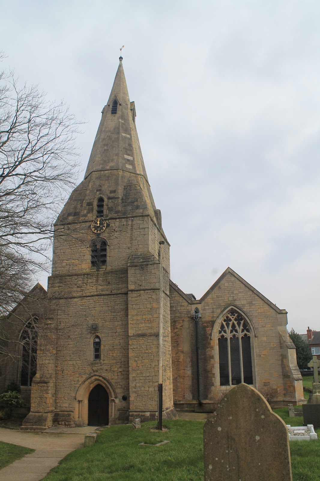
I'd really been looking forward to going to Chesterfield, having passed through the town once before, on my way to Sheffield and being intrigued by the curiously twisted spire of Chesterfield's parish church, the Church of St Mary and the All Saints (sounds a bit like a girl band, doesn't it!).
The church is Chesterfield's most interesting sight and it is truly remarkable to behold. It caused quite a flurry of interest, when I posted some photographs of the crooked spire on Facebook! There are different theories, as to why the spire is crooked, but my favourite explanation is that it's a result of bad craftsmanship because a plague killed off all the local builders!
 |
| Chesterfield's Crooked spire |
This was to be our first and last foray into Derbyshire, which isn't particularly famous for its Roman settlements but has always been on the way to other places, being on the main road north from London to York.
 |
| Sign for Chesterfield College |
 |
| Symbol of strong arm on Chesterfield's Knifesmithgate |
Due to train times and Friday evening ticket prices, myself and BAM (Best Aussie Mate) had committed to leaving London early in the day, guiltily sloping out of our respective offices just after lunch and arriving in Chesterfield with a few hours to spare before the sun went down, which gave us a chance to walk around the town centre and check the place out.
 |
| Chesterfield Borough Council |
Lodgings and victuals
We had a very comfortable stay in Chesterfield, at the ultra-modern Spire View @ the
Galleon Steak House (so modern it even has an @ in its name!) As our accommodation was above the steak house, we were quiet conveniently located for dinner and we would highly recommend the steaks at the Galleon, if you ever find yourself in Chesterfield.
We were quite impressed with Chesterfield itself. It's a handsome town, with lots of Georgian architecture and a really pretty market place with an Italianate town hall. Some of the black-and-white striped tudor-style buildings are in need of some TLC, but the town was prettier than I expected it to be and we enjoyed walking around Queen's Park, as the light began to fade.
 |
| Chesterfield Unitarian Chapel |
 |
| The Boating Lake at Queen's Park |
 |
| Chesterfield Market Place |
Bolsover to Woodthorpe (3.2 miles)
Some of my colleagues from 'up north' looked a bit appalled when I said we were planning to start our walk in Bolsover, a small village about 5 miles to the east of Chesterfield. Apparently,
Bowser doesn't have a great reputation and is looked down upon by neighbouring Chesterfield as being a bit rough.
 |
| Distant view of Bolsover Castle |
We thought Bolsover was alright - jumping off the bus on Station Road, we made our way up to Bolsover's impressive castle and had a nosey around the castle gift shop. BAM caused a bit of consternation, knocking over a display of cards and then getting into a battle of hard stares with the shop assistant, who seemed to be very confused by the fact that we'd just come to see the gift shop and had no intention of visiting the castle!
 |
| Bolsover Castle - which we didn't visit! |
 |
| Bolsover St Mary and St Lawrence |
Bolsover has a lot of potential and there are some pretty, historical buildings around the village, although it is also surrounded by some grim-looking housing estates.
 |
| Housing estates surrounding Bolsover |
We knew that the first part of our walk, from Bolsover to Woodthorpe would be the trickiest, as there is no waymarked trail through this part of the Derbyshire, but we were relying on a series of connecting public footpaths, which can be hard to find, especially in winter time, when they seem to disappear into the tilled fields.
We'd purposefully organised the walk in this way, so we could do the most challenging bit first and then have the easier way-marked trail into Chesterfield later in the day, when we would, inevitably, be feeling a little bit more tired.
 |
| Public footpath through Derbyshire countryside |
From Bolsover we followed the Shuttlewood Road to the end of the village, with some fine views over the Derbyshire countryside, we followed a public footpath downhill towards the B6418 and Bolsover Woodhouse farm.
The hardest part of the walk was at the farm, which was a stud farm and where, unfortunately, the owners had blocked the public right of way and we found overselves floundering around in the mud, in an enclosed farmyard with some panicking horses. It was a relief to get out onto the roadside again, where we picked up another public footpath, a more defined one this time, going in the direction of Woodside Farm.
We got a bit distracted at this point and waylaid by a rather big road that has been cut into the hillside and which took us away from Woodside Farm and straight over towards the M1. The M1 is quite an impressive motorway and I've been on it quite a few times before, when I used to catch the bus up to Leeds to visit my sister. It was built in the 1960's and cuts an impressive chunk out of the Derbyshire countryside.
 |
| Distant view of Woodside Farm |
I thought of all those people in cars, lorries and buses. listening to music on the radio, as they made their long journeys north and I was extremely thankful, to be outside in the fresh air, enjoying the countryside. We were as horrified by the sight of cars on the M1, as the drivers would have been of walkers in the fields nearby, if they'd been travelling slowly enough to see us!
 |
| M1 near Woodthorpe |
We ended up crossing the motorway a bit further south than we'd intended but, yet again, another convenient road appeared on the far side of the M1, part of a new housing development, which led us straight to the village of Woodthorpe.
 |
| Building site just outside Woodthorpe |
We sat on the public bench in the middle of Woodthorpe, at the top of Norbriggs Road, munching on fruit and nuts and talking about the difference between the Comoros Islands and the French overseas region of Mayotte.
 |
| BAM in Woodthorpe |
Woodthorpe to Staveley (2.2 miles)
It's been quite cold this past few weeks, so we didn't hang around on the bench for long, as our hands were freezing and we soon set off down the Norbriggs Road toward the houses at Norbriggs. We then followed another public path called the Norbriggs Cutting and eventually joined up with the Cuckoo Way, which soon joined the Chesterfield branch of the Trans-Pennine trail and took us to Staveley and the Chesterfield canal.
 |
| A Cuckoo waymarker |
We've walked on the Trans-Pennine trail before, when we did our
Doncaster walk almost three years ago. The comedienne, Jo Brand, has just recently completed the Trans-Pennine trail and I was lucky enough to see her talking about it on the Jonathan Ross show, when I was in the audience for the live recording a few weeks ago.
We've done quite a bit of canal walking in our time and Chesterfield Canal was quite a pleasant canal to walk along. It's one of the oldest canals in England and played a key role in the transport of coal from Staveley to Chesterfield. I convinced BAM to stop and help me cut some rushes near the canal bank, as I wanted to make a St Brigid's day cross.
 |
| The Chesterfield Canal at Staveley |
Staveley to Brimington (2.7 miles)
The day had brightened up quite a bit by the time we got to Staveley, so the canal walk was relatively busy with dog-walkers and couples with children. The countryside roundabout is unremarkable, but quite a pleasant and quiet place to let your thoughts wander, as you make your way back to the town. Interestingly, the Chesterfield canal is quite curvy and not set in a straight line, like most canals we've seen previously. It meanders, much as a river would.
 |
| The canal near Brimington |
Brimington to Chesterfield (1.5 miles)
The landscape becomes noticeably more urban, as you get closer to Chesterfield and this isn't the nicest part of the canal. We had a few hours to spare, as we finished our walk quite early and our train wasn't due to leave until half past seven, so we took our time and had a nice meal in a restaurant called
Ephesus, which is, no doubt, named in honour of the former Greek city in Anatolia (now
Efes in modern-day Turkey).
 |
| Only 2,500 miles to Istanbul! |
We also managed to squeeze in a quick drink at the White Swan, on Saint Mary's Gate, just opposite the church, before making our way back down to Chesterfield station and our train back to London.
 |
| Chesterfield Old Railway station building |
Access for Wheelchair users:
 |
| The Canal tow path is pretty accessible |
The walk described above would be completely inaccessible from Bolsover to Staveley, however, the paths alongside the Chesterfield canal appeared to be quite accessible and that would be the most logical local route for wheelchair users.
Image credits:
All photos were taken by me - please feel free to reuse them under the following Creative Commons license:
Attribution (especially to this blog post)
Share-alike
Non-commercial


No comments:
Post a Comment